Applying What You Know: Reading the Built Environment

Learning to read your built environment – your city – helps you to form tangible connections to where you live. In turn, your sense of place and community increases. You feel ownership and responsibility for your town or city, which allows for better planning and smart development. The longer you live somewhere and study, the better you get to know a place; the more you love it.

But what happens you go someplace new? How do you read the built environment if you know nothing about its history? Good question. The best part of learning to read the layers of the built environment is that you can gain a sense of place and understanding without needing to know its cultural history. How do you do that?  By observing and translating the elements of the built environment you see the development and changes.

Elements of the built environment include street patterns (gridded or not?), buildings (height, architectural style, materials), parking lots (where? garages?), sidewalks (width, material?), landscaping (trees?), bridges (type?), utilities (underground wires or telephone poles?), and more.

I want to share an example that I used in my recent Built Environment lecture. It’s simple, but a good place to start. Ready to play along? And, go!

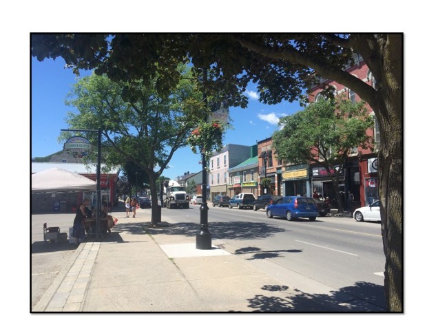
Recently, I traveled through Prescott, Ontario, a town on Canada Route 2 along the St. Lawrence River. I stopped in what appeared to be the center of town. As a preservationist, I always enjoy getting out of the car and wandering for a few blocks to snap photos and observe the area, stare at buildings – that sort of thing.

Here is the view standing on the corner of Centre Street and Route 2. Note the historic building block on the right. On the left, however, is a large parking lot. Parking lots always raise an eyebrow for me – why is there a large parking lot in the center of town? Historically, towns were not built with parking lots in the middle. Let’s have a look around.

Slide1

Parking lot (left) & historic building block (right) in the center of Prescott.


Slide2

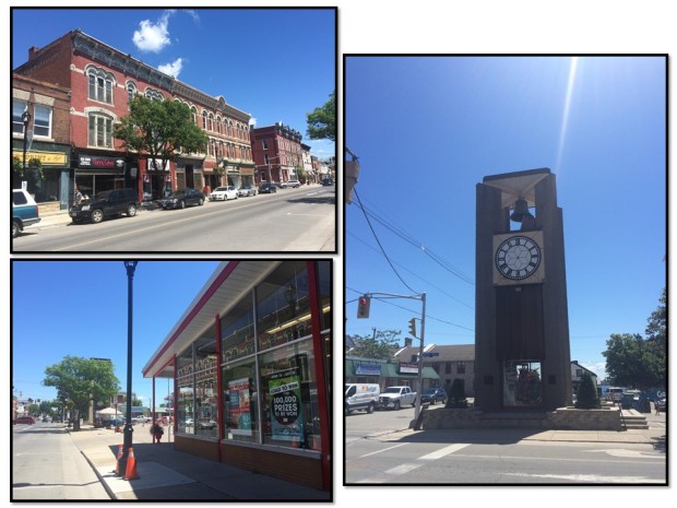
Top left: the same historic building block mentioned above. Right: tower and parking lot at the SW corner of Route 2 and Centre Street. Bottom left: The same parking lot as seen from the other end of it (note clock tower behind the tree).


You can see the photos above. Now let’s step across the street. These Google street views (below) show that SW corner (in the first photo I stood next to the clock tower).

Once I did a 360 observation of the block I had a few guesses. In the United States, if there is a hole (read: parking lot) in a town or city, I automatically think 1960s Urban Renewal era. However, this was Canada, so I wasn’t sure on Urban Renewal.

But, the drug store adjacent to the parking lot had a mid 20th century vibe (see image below). The general automobile culture (1950s/60s) often falls in line with demolition and parking lots for auto-centric businesses.

Slide3

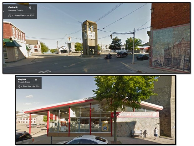
Google Street views of the corner and drug store.

My guess? A historic building was demolished for the drug store and parking lot, and the clock tower built on the edge of the parking lot to “honor” the historic building. Classic, right? Always the preservation nerd, I did some Googling to see if I could find information about Prescott development. It took a while, but eventually I did find my answer!

Yes, there was a historic building there. This one:

Slide4

Prescott, Ontario 1876 Town Hall. The clock tower was a later addition.

According to this source, the town hall was demolished in the early 1960s due to neglect and lack of available funds in the town for repair. While I couldn’t find when the drug store was built, I have a pretty good guess that it followed shortly after demolition of the town hall.

While this was not the most uplifting example of reading the landscape, it is important to understand how our cities and towns are shaped by individual projects and decisions. And the lesson? When you see a large hole in the center, spin around and look around. It’s probably not supposed to be there.

Preservation Photos #180

Historic preservation at work: sidewalk construction in Jamaica, VT.

Historic preservation at work: sidewalk construction in Jamaica, VT.

Historic preservation is part of all sorts of projects, especially sidewalk construction (or reconstruction) in historic villages. Sidewalks encounter contributing features such as walkways, hitching posts, markers, landscaping, fences, and trees, as seen above. This photo shows sidewalk construction ongoing and tree protection barriers in place. Note the tight squeeze of the sidewalk between the trees and the historic properties.

Preservation ABCs: L is for Landscape

Preservation ABCs is a series that will work its way from A to Z, bringing words into conversation that are relevant to historic preservation, whether it’s an idea, feature or vocabulary term. The idea is to help you see preservation everywhere you look and wherever you go. Enjoy! See previous letters.

————————–

L is for Landscape

Windham County, Vermont, agricultural landscape, October 2009.

The word “landscape” likely triggers images of rolling hills, the coast, mountains or flat farmland. When discussing historic preservation and landscape, those images still hold true, except landscape is more aptly called “cultural landscape” by the National Park Service. Basically, cultural landscapes represent how humans have modified the environment and interacted with the land.

There are four types of cultural landscapes: (1) historic sites (2) historic designed landscapes (3) historic vernacular landscape and (4) ethnographic landscapes. Preservation Brief 36 explains cultural landscapes succinctly. Subtypes of these four types range from highways to parks to neighborhoods to farmsteads to battlefields to gardens to sacred sites, among many more.

Like other historic resources, landscapes have boundaries and historic context and significant features that contribute to their integrity (think of the threats to battlefields for a reference). The National Park Service maintains the Cultural Landscape Inventory (CLI) of all cultural and historic landscapes across the country. Cultural landscapes are an entire field of study, obviously much too lengthy for a single post, but visit the CLI to get started. (And if you’re a cultural landscape expert, feel free to add more as a primer.)

Aside from the NPS definition of cultural landscapes, “landscape” can refer to everything around us. When you read your landscape, you are reading every element (not necessarily historic) of your environment and understanding the place where you live: what existed before and what exists now. Reading landscape is important because it allows preservationists and others to understand “sense of place” and what makes a place unique.

So think about your landscape? Do you know of any designated cultural landscapes around you? If not, how would you describe where you are?

Preservation ABCs: G is for Gateway

Preservation ABCs is a series that will work its way from A to Z, bringing words into conversation that are relevant to historic preservation, whether it’s an idea, feature or vocabulary term. The idea is to help you see preservation everywhere you look and wherever you go. Enjoy! See previous letters.

————————–

G is for Gateway

This pony truss bridges is a gateway to the Woodstock Village Historic District.

A gateway is an indication on the landscape or in the built environment that you are crossing to a new setting. This indication is a tangible change in the environment. Think of a gateway like an entrance to someplace new; however, gateways are more than gates and fences, of course. A gateway might be a bridge, stone walls, landscaping or a settlement pattern that gets denser as you approach the center of town. A bridge is a gateway to a historic district because it anchors one side of the district boundary. Upon crossing that bridge, you are entering the village or historic district.

Gateways are important because they allow us to read the landscape as we travel and to recognize communities. Because of this, our historic bridges are important to maintain and rehabilitate. Removing a truss bridge or an ornamental concrete railing to be replaced with a standard highway bridge will change how you read the landscape. Historic bridges signify crossings and entrances.

Towns and neighborhoods do not need a bridge in order to have a gateway. Sometimes when an “entrance” to a village is less obvious, due to development and sprawl, towns will employ welcome signs and banners or other landscaping elements. The street might be narrower or sidewalks begin at a certain point. These are examples of reading the more subtle hints of the built environment. New development and even shopping malls today attempt to create the feeling of gateways by lining the traffic lanes with ornamental street lights and banners, using pavers or dyed concrete.

When you cross that gateway maybe you get the feeling that you are in a settled area, a more human scale area as opposed to the wide open spaces or the sprawl development. Take a look next time you’re traveling.

Think about this: how do you recognize when you enter your town? What does the approach into your neighborhood look like? Would you say that it has a gateway?

Preservation ABCs: B is for Bridge

Preservation ABCs is a series that will work its way from A to Z, bringing words into conversation that are relevant to historic preservation, whether it’s an idea, feature or vocabulary term. The idea is to help you see preservation everywhere you look and wherever you go. Enjoy! See previous letters.

————————–

B is for Bridge

A historic plate girder bridge on an active rail line in Richford, VT. Historic bridges come in all shapes, sizes and structures.

A bridge carries a road, rail line or other traveled way over a watercourse, landform or even other thoroughfares. Most will think of our great bridges such as the Brooklyn Bridge, the San Francisco Bay Bridge, the Verazzano Bridge, the Lake Champlain Bridge, Scotland’s Fourth Rail Bridge, the London Bridge and other engineering marvels. But like that photograph above, a simple plate girder bridge on the rail line, small bridges play an important role in our history and landscape as well.

Bridges are constructed of wood, iron, steel, concrete or stone. The technology of bridge engineering is endless but a list of common types includes covered, wood truss, metal truss, concrete arch, masonry arch, girder, suspension, cable stay — you have probably heard many of these terms.

Although we could discuss bridge engineering and delve into types of trusses and structural systems, the better lesson of these Preservation ABCs is to understand why bridges are important on the landscape. If you’re not an engineer or a preservationist working in the transportation world, why do bridges matter to you? There are a few simple reasons to share.

First, bridges are part of our collective settlement patterns and how we move throughout the landscape, where we go, how we cross uneven landforms or waterbodies. Many bridges we can see on the landscape as we travel up hills, down hills or approach from the distance. Bridges signal a change in the ground beneath our feet and our vehicles. They allow us to read our environment.

Second, bridges are integral parts of our communities. While more than indications of a change in landscape, bridges serve as the gateways to communities, large or small. Bridges are visual structures just as buildings, which hold stories, memories, history and contribute to historic districts and settings. Even without understanding the engineering, it is feasible to read a bridge by its materials, design and railing ornamentation. This will place the bridge in a certain time period. For example, many truss bridges in Vermont were constructed following the 1927 flood, which destroyed hundreds of bridges. These are standing reminders of that period in history.

Third, the construction and engineering of bridges represents advances and lessons in our technology and the reach of our resources. Many early bridges, such as wood truss bridges in Vermont, were constructed by hand with local materials, based on the know-how of locals. Why? Because that is what was available. Iron could not be forged and shipped across colonial America. As technology changed, the industrial plants developed, the population and knowledge base grew, roads improved, ideas shared more easily, etc. every community had greater access to materials, experts, plans and technology.

There you have it: reading the environment, being an integral part of history and current communities, and telling the story of technology and innovation. The list could go on. Maybe you just like the aesthetics of bridges. That’s a good place to start, too.

These ideas and reasons for the importance of bridges are intertwined, but hopefully aid in appreciation as to why our historic bridges matter.

Spotted Roadside: Water Tower

water_tower.jpg

Somewhere in Virginia (I wasn’t navigating!)

 One thing that I associate with my travels in the midwest and my days living in North Carolina are gigantic water towers, like the one in the picture above. Often times, towns each have their own water towers, which are adorned with the town name or something to that effect. When I moved to Vermont, I noticed a lack of water towers (though there is one on the University of Vermont campus, which is the only one that immediately comes to mind. Anyone else?). So whenever I’m on the road in other parts of the country, it’s a familiar landscape feature – a good landmark for distance and geographic location. Do you like water towers?

Pop Quiz Follow Up

Preservation Pop Quiz and Answer. To give you a better image of the underground telephone line markers/posts that you’ll see along the road, here is a picture of one without the faded plaques.

Click and zoom for detail.

Keep your eyes open!

Preservation Pop Quiz

Now that I’ve noticed these on the side of the road, I can’t stop noticing them. Maybe it’s an obvious feature to many, but it took me a while to realize what it is. What is your guess? And how often do you notice these?

20120621-083917.jpg

What is Your Community Wish?

It’s summertime (just about) and the weather beckons us to appreciate our downtowns and the surrounding landscapes, whether you prefer strolling in the commercial district, spending the day in a park or taking an adventure. What is your favorite summertime activity? How do you show your love for your community?

Strolling through historic downtown St. Albans, VT.

Part of loving your community means considering where it is going. What would you like to change about where you live, or what would you like to add? Maybe it’s something as simple as benches in the park. Or maybe you’d like to see more businesses in town. Perhaps a historic building in town needs some help. Get out, enjoy the sunshine and daydream about your “ideal” place to live. You never know, you could be thinking the same thing as many others. Don’t be afraid to bring up your idea.

Preservation Pop Quiz

Today’s quiz is inspired by the types of questions that Prof. Bob McCullough asks of his History on the Land students. He provides a picture and asks students to read the landscape. What do you see in this picture? What does it infer? What does it tell you about the landscape?

What can you decipher from this photograph? Click and zoom for additional clarity (this is a large file).

Have fun! I’ll post my interpretation, too. Other Preservation Quizzes from PiP:

Note: The Sense of Place mini-series will continue on Monday.