Playground History: David Aaron and ALCOA

Happy New Year, friends! I hope 2021 brings you good health, happiness, prosperity, and may it bring peace as well. I think a good way to start 2021 on Preservation in Pink is with a fun playground post. This is the one I referred to as “waiting in the wings.” I hope you enjoy it. Thanks for sticking around, preservationists and friends. 

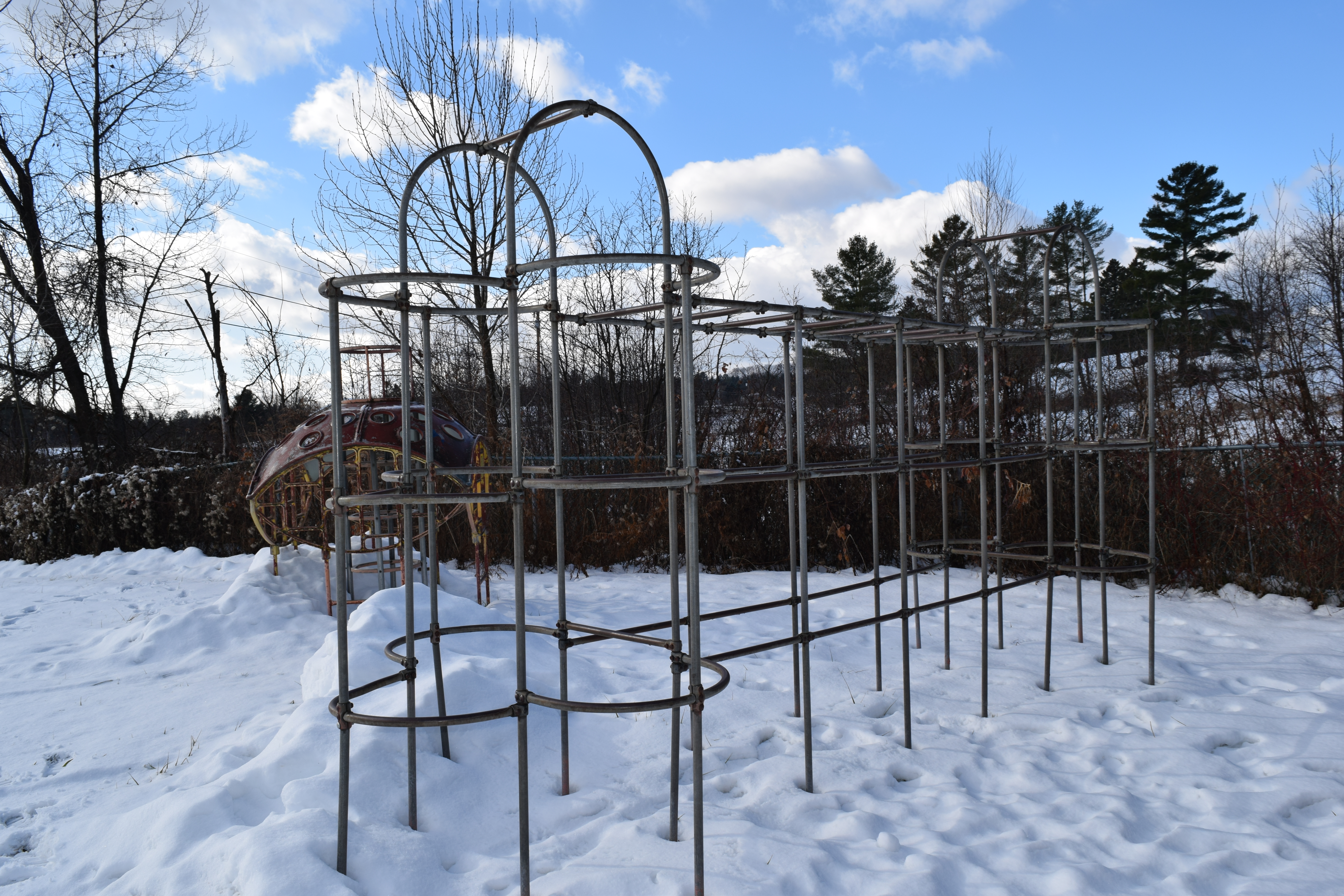
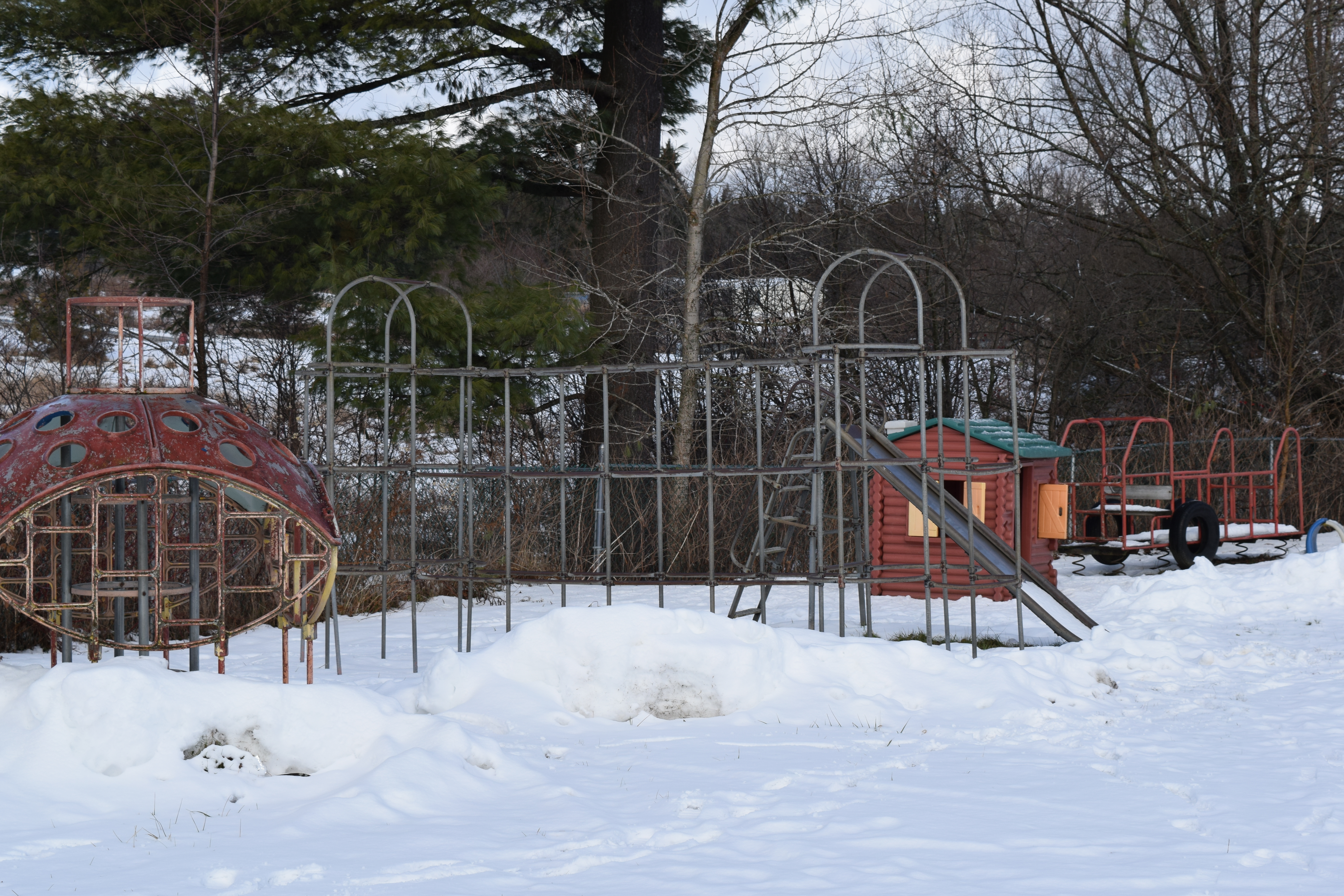
Last winter, I wrote about a playground in Brownington, Vermont. On the playground, I found a mysterious piece of playground equipment – one that was new and unusual to me. Internet searching led me to find identical pieces, but no information about it. Readers and Instagram followers assumed what I did – a space age era piece of playground equipment, but nothing definitive.

Fortunately, an Instagram acquaintance (@followthebreadcrumbs2) gave me some information about this apparatus. She said that she was fairly certain it was designed by David Aaron and manufactured by Alcoa (Aluminum Company of America) in the 1950s. A quick search using that information and she was right. That was exactly the information I needed, and it made my day (yes, yes, I’m a playground nerd).

DSC_1184
Found in Brownington, VT. 
Space Age Playground at Sterling Forest Gardens, Tuxedo, NY.

Historically, playground equipment was made of steel. Aluminum had been widely used during the war years as a component in airplane manufacture. As part of its strategy to win new markets after the end of Word War II, Alcoa tried to catch the interest of the design community and make the consumer comfortable with this material (source: http://architekturfuerkinder.ch/david-aaron/).  This effort was known as the “Forecast Program”. For this venture Alcoa focused on the designer as ‘the man to stimulate the consuming public with inventive projects for the home”, and invited a range of designers including Isamu Noguchi, Alexander Girard, Charles and Ray Eames and many others to participate, including David Aaron. What Alcoa wanted from the designers was not a product to manufacture, but a concept to promote.

“With the new Forecast design, aluminum is given its first serious introduction into outdoor playground applications. The lightweight, rust-proof characteristics of the metal, – plus its ability to be colored, make it a maintenance-free, “natural” for playground use. The climbing tree is scheduled for actual production by Creative Playthings, Inc., New York City.” The “tree,” other Forecast items, and products of Massena Operations of Alcoa was on display during “Aluminum Days” of the Massena (NY) Vacationland Festival (1958).”

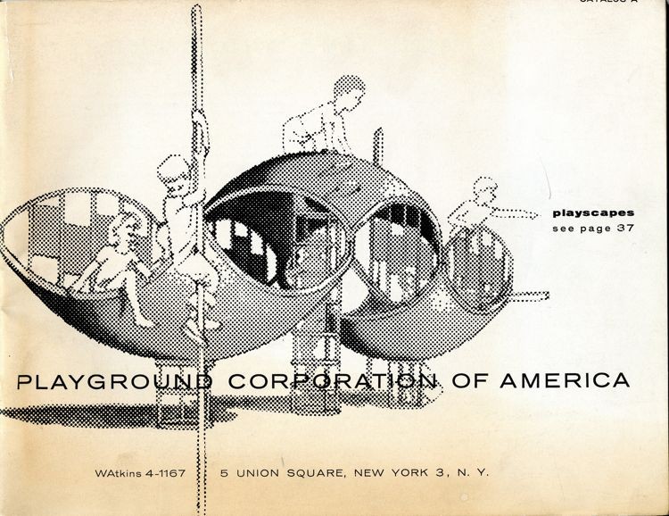
Additionally, David Aaron was the Director of the Playground Corporation of America. Mr. Aaron designed  these midcentury pieces called “play shell-ters” with 13 designs for ages 18 months to 13 years, according to the 1959 Playground Corporation of America Catalog. 

1959 Playground Corporation of America Catalog. Image found here: David Aaron – The Playground Project Architektur für Kinder (architekturfuerkinder.ch)http://architekturfuerkinder.ch/david-aaron/

The September/October 1965 Playground Corporation of America information booklet titled “Park Practice Grist” discusses new concepts in playgrounds, specifically some that allow children to play independently, energetically, even with short attention spans, while growing and learning confidence. Playgrounds were designed to stir the imagination; each playground apparatus could be whatever a child imagined. And because equipment was stationary (unlike swings or merry-go-rounds), it was thought to be safe. The booklet describes “shell-ters” as: 

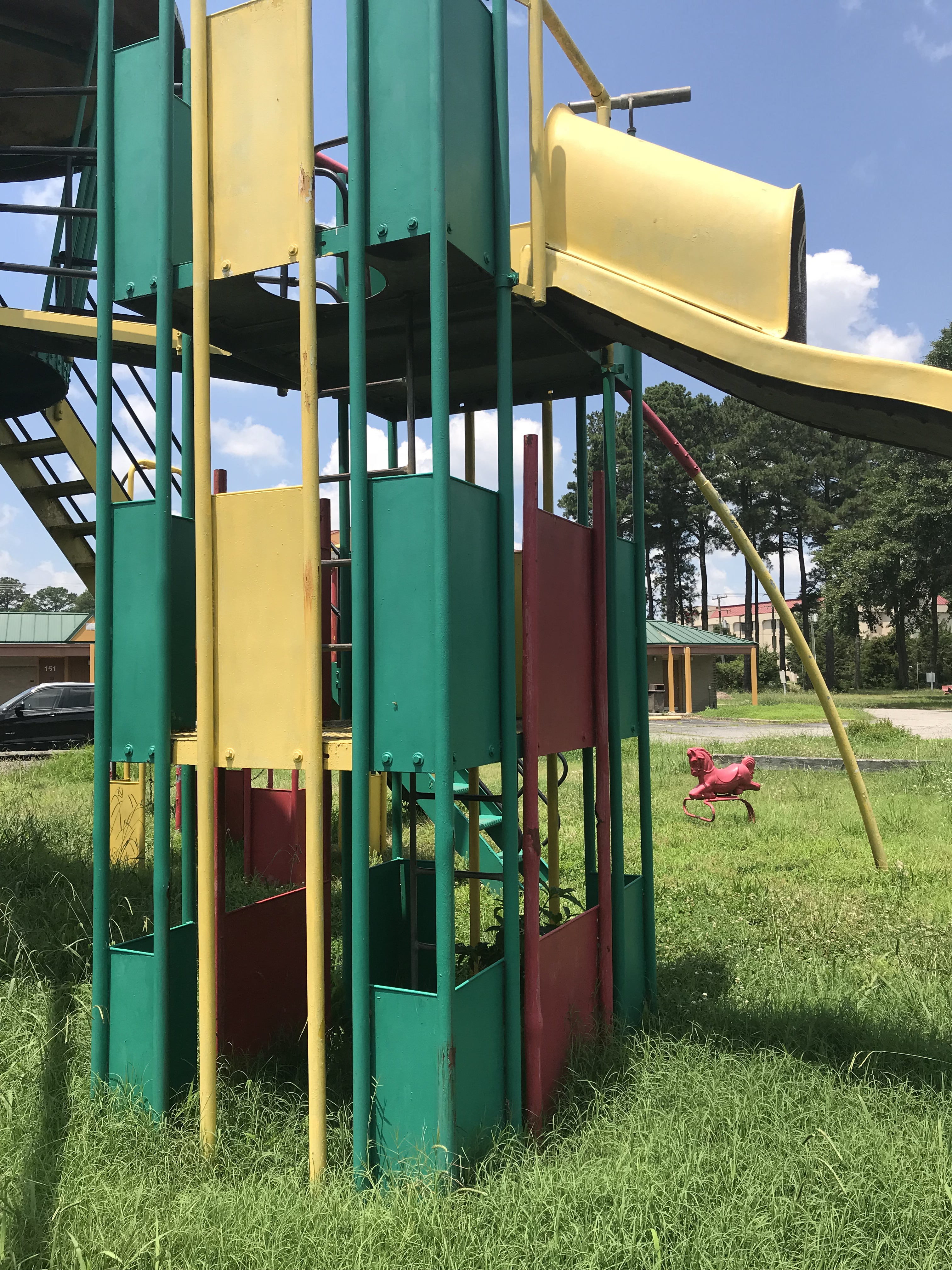
Dome-shaped shells of cast aluminum are caves, ships, playhouses, crows’ nest, forts…whatever busy young imaginations proclaim them to be. They can be installed concavely or convexly or upended to form curved walls. They are used in a variety of ways in combination with sliding poles and/or with such climbing apparatus as cylindrical “ring dings’ and grill like “wing-dings’. These versatile shapes are made of non-corrosive aluminum, require no maintenance. 

A “shell-ter” at a playground. Photograph by Scott Hocking. https://www.scotthocking.com/jmm.html

David Aaron’s obituary reads:

David Aaron, a designer of playgrounds, died of a heart attack Tuesday at his home in Accord, N.Y. He was 60 years old. Mr. Aaron was the founder of the Mid-Hudson Institute of Community Design for the Young in Poughkeepsie, with which he was associated at the time of his death. Among his creations were the playground for the United States pavilion at the Moscow Fair in 1959, the Playground of Tomorrow at the 1964-65 World’s Fair in New York and the playground at an elementary school in Bronxville, N.Y. He is survived by his wife, Maia; two sons, Peter, of Brooklyn, and Michael, of Chicago; a brother, Howard, of Bridgeport, Conn., and one grandchild.

Thank you to David Aaron for your devotion to playgrounds and creative play.

This was much more information than I was expecting to find about a single playground apparatus. I still don’t know why a single piece of playground apparatus was placed behind a church in Brownington, VT. Perhaps something second-hand from a school or a town park? Or one piece specifically purchased for the church? If anyone knows, I’d be thrilled to learn.

Theories of play and playground equipment come and go like all trends; it is interesting to find historic playground equipment – usually on private property or in rural areas. Have you seen any of these pieces at playgrounds?

Playground Find: Brownington, VT

Brownington, Vermont is located in the Vermont’s “Northeast Kingdom” (Essex, Orleans, and Caledonia counties), about 15 miles south of the Canadian border. It’s a very rural, picturesque part of the state. I was surveying a few properties in Brownington, VT for a work project and wanted to snap a photo of the church in Brownington Center.

DSC_1179

Brownington Center Church, 1854.

DSC_1181

Brownington Center Church, 1854.

Distracted by the building, I almost missed this gem behind it! 

DSC_1180

Vintage playground equipment sitting behind the Brownington Center Church!

Of course, I got out of the car to get a closer look at the playground equipment. First up – a classic 1950s jungle gym (see photos below). The American Playground Device Company (now the American Playground Company) produced similar looking jungle gyms in the 1950s. An easy way to distinguish earlier jungle gyms from 1950s jungle gyms is the rounded elements of the 1950s jungle gyms as opposed to the non-rounded and overall square structures of earlier versions. This jungle gym has “ST. JOHNSBURY, VT” stamped on one of its pipes. St. Johnsbury, is a larger town about 36 miles away from Brownington. Perhaps this was a hand-me-down piece?

DSC_1188DSC_1185DSC_1201

Next up, the slide. Slides are a little harder to date, but based on the design, it appears to be another 1950s apparatus.

DSC_1191

This slide is sinking into the ground.

DSC_1190

DSC_1189

Recreation Equipment Corp. Anderson, Indiana. 10-A. (Does anyone know what the 10-A represents?)

Next up: the mystery apparatus. I don’t even know what to call this one. It dates to the 1960s space age era of playground equipment, but nowhere can I find a name for it or a specific manufacturer. It’s part spaceship, part jungle gym, part submarine, part ladybug? Take your best guess. Do you recall playing on something like this?  DSC_1182DSC_1184

I’ve found a few similar images while searching online, but no luck with names. Do any of these ring a bell? Sources are in the photo captions. Click on each image or on the following links (clockwise, starting at top left): Photo 1, Photo 2, Photo 3, Photo 4. Any help in giving these a name or manufacturer would be much appreciated!

And what is an old playground without a merry-go-round? This is a later version, likely the 1970s, which you can tell by the shape of the handles and the pattern of the metal treads. It still spins – I checked! DSC_1193

Behind the merry-go-ground is an assuming fire truck. These types of play structures were common in the 1970s as well. DSC_1195DSC_1197

And that concludes the tour of the Brownington Center Church playground: pieces from the 1950s – the present (note the plastic playground pieces I did not feature). I hope kids are still enjoying these pieces.

Brookside Cemetery, Chester

‘Tis the season for cemeteries, foliage, and foggy days. Brookside Cemetery sits in the center of Chester, a picture perfect town in southern Vermont. It is a historic, intact, linear later 18th century to early 20th century Vermont village. The cemetery is located between the Chester Historical Society (the ca. 1881 brick schoolhouse) and the 1835 Baptist Church. Across the street is the town green and on the other side of the green is a beautiful, intact row of a historic buildings. Brookside Cemetery has been in use since the 18th century; the earliest headstone dates to 1770. In New England tradition, the burials face east and the stone lettering faces west. Even on a gloomy fall day, it’s peaceful. Take a look!

img_2771

Looking to the schoolhouse and the cemetery.

img_2779

View to the Chester Historical Society. 

img_2790

Headstones.

img_2785

img_2777

The main entrance to the cemetery; this fence dates to 1867.

img_2776

The 1850 Public Tomb was constructed of granite block cut in nearby Gassetts, VT and transported by train to Chester Depot.

img_2774

The 1830 Hearse House is a museum as of 2017.

img_2780

The main entrance road is lined with cedar trees. The road was laid down and the trees were planted in 1867, inspired by the Mount Auburn (MA) Cemetery and the rural garden cemetery movement.


Interested in learning more about Chester?

  • Read more about Chester’s Brookside Cemetery here.
  • Read the Chester Village Historic District National Register nomination here.


Tourist Cabins: West Shore Cabins, North Hero, VT

Summer is winding down, but fall in Vermont is a perfect time of year to visit. The humidity has decreased, the leaves are changing, and you can readily find apple cider doughnuts to go with your craft beer. Take a drive on U.S. Route 2 and you’ll pass through the Champlain Islands (or “the Islands”). The Champlain Islands offer a completely different feel than central Vermont. The land is flatter, mountains are in the distance, the lake is visible for much your drive, and fall arrives a bit later than in the mountain towns. It would be a lovely time of year to stay in a tourist cabin on Lake Champlain. I’m happy to report that there are more tourist cabins operating in Vermont!

The West Shore Cabins are operating tourist cabins located adjacent to Lake Champlain on U.S. Route 2 in North Hero, part of the area known as the Champlain Islands. What began as the West Shore Inn in 1927, became the West Shore Cabins in 1945. At that time it was run by the Donaldson family who saw how a motor court would be a good economic venture as automobile traffic increased in the mid-20th century.  Some cabins were relocated to this site and others were constructed on site. Today the family operated business offers five cabins for daily or weekly rentals from May – mid October.

West-Shore-Cabins-History-Pic-3

West Shore Inn postcard. Image via West Shore Cabins.

DSC_0560

The vintage sign between the lake and U.S. Route 2.

DSC_0561

West Shore Cabins sit on U.S. Route 2 with a clear west view to Lake Champlain and its sunsets.

DSC_0554

The cabins retain much of their historic integrity including siding, porches, windows, and fenestration.

DSC_0552

Novelty siding, exposed rafter tails, screened porch and a barbecue out front; Cabin 5 is adorable.

DSC_0551

Cabins 4 and 5.

DSC_0548

Cabin 1.

DSC_0553

DSC_0547

The cabins are set back from the road, with no obstructions to the lake views.

DSC_0549

Ca. 1880 (with later alterations) residence associated with the owners of West Shore Cabins.

Happy end of summer! Let me know if you find more tourist cabins and/or stay in one!

Demolished New York: Massena High School {or: How to Answer “What Used to Be Here?”}

Demolished? It’s a variant on “Abandoned” posts, yes. However; it seems like a good way to show you the mind of a traveling preservation (or at least how mine works). What does a preservationist think about when traveling? And how does a preservationist find the answer to her question? I’ll use Massena, NY as an example, which I visited earlier this summer.

Massena, NY is a town located on the St. Lawrence River in northern New York, just south of the Canadian border. Once economically supported by the railroad and a canal, the car manufacturer, GM, along with Reynolds and Alcoa, Massena has seen better days since GM closed in 2009, removing billions of dollars from the local economy. However, the town has a good stock of historic buildings with tree-lined side streets showing its former prosperity and its potential. We enjoyed walking around town studying its current state and wondering about its past.

img_1335

Downtown Massena: underground utilities, sidewalk pavers, trees, storefronts – it is clear that there has been investment in this town not too long ago.

img_1331

The 1918 Strand Theater on Main Street is currently closed, but rehabilitation efforts are in the works.

img_1333

Theater plans in the window.

img_1332

Massena Downtown Theatre Association – see here http://massenadowntowntheatre.com/

The remainder of the small downtown “main street” includes abandoned buildings (such as the School of Business), building under rehabilitation, empty storefronts, occupied storefronts, a hotel, a post office, and some stores.

img_1336

This corner building holds a gym on the first floor.

img_1339

The rehabilitated bridge over the Grass River.

Outside of the downtown block are tree-lined residential streets with sidewalks and historic houses with front porches. There is a large park between Clark Street and Danforth Street (see map below) with a monument in it. It’s part sign, part monument, you could say.

massena park aerial

img_1325

Massena High School sign and school bell installed in the park.

img_1326

Memorial sign.

img_1327

The park and former school grounds as they appear today. The sign is behind me in this photograph.

I wondered what this sign was doing here, oddly located, in the middle of an empty park with nothing else. Where did it come from? A quick look on the map showed it labeled as “Wooden Park.” Other maps showed it as “Old Bridges Avenue Junior High School.” It seems like an odd spot for a school building, as the lot is fairly narrow. There certainly was no parking. What did it look like, if it was a school? When I have a question like this, I turn to historicaerials.com, which usually answers my question. See below. The school filled the entire space between the streets.

massena high school

The school is in the center of the photograph with Clark Street on the left and Danforth Street on the right. Note the courtyard in the middle of the school.  Photo: historicaerials.com

massena1976

Massena, 1976.

And, of course, I search for images on Google or Cardcow.com or eBay. In this case I searched for old “Massena High School” NY. I vary the quotation marks until I find what I’m looking for. When you have a common phrase such as “high school” it’s best to use it in quotes with its name, otherwise you’ll have an endless list of search results. Fortunately, this search wasn’t too difficult.

High School Massena, NY

Massena High School. Source: cardcow.com

massena high shcool photo

Massena High School (later Junior High School). Source: http://www.topix.com/album/detail/massena-ny/R3V9PSPSATQBVQOU. Thank you, kind strangers, who post information about your hometowns on the internet.

The high school was closed after the 1980-81 school year and demolished in 1986. I was unsuccessful in discovering why it was removed, but I would guess it had to do with expensive upgrades and maintenance issues. In its place a wooden park was constructed in 1990 and removed in 2015. It was officially known as the Danforth Place Creative Playground. Walking across the grass, you can still find wood remnants of the playground. The playground was removed due to deterioration and increasing vandalism and illegal activity on the playground.

And that, my preservation friends, is a simple way to find out answers to “what used to be here?” What tricks do you have?

Rare Playground Find: Miracle/Jamison 1975 Mark IV Imagine City

Playgrounds from the 1970s are almost extinct, at least the interesting (read: fun) equipment. Finding one in the wild is a treat and a scavenger hunt. By pure luck, while driving south on I-95 in Virginia, I caught a glimpse of what looked like a playground. I saw a metal spaceship-looking apparatus, which I assumed was a playground – or a carnival ride. Unable to switch lanes and get off at the exit, I made a mental note of the mile marker so I could search later.

Since I could knew it could be seen from the interstate, I traveled up and down I-95 on Google Earth until I spotted what looked like the spaceship playground (how I described it in my head). With the help of Google Street View, I found it! I was pretty certain I knew the manufacturer of the playground at this point (because I am a nerd and spend lots of time studying historic playgrounds). Fortunately, I had the return trip to look forward to so we could stop and check out this playground.

The playground is set between the interstate and a questionable motel that appears half operating, half closed. The restaurant on the property is closed and any reviews you read of the hotel are terrible. To get to the playground, you have to drive around to the back of the hotel.

This is what I expected to find (bottom right):

Miraclecatalog1974

Parks & Recreation August 1974. Source: Nels Olsen, Flickr (username: nels_P_Olsen).

And this is what I found:

IMG_4483

Playground view from the parking lot (June 2018).

It matches! I’m not ashamed to say that my excitement rivaled that of my childhood self. And if it weren’t 100 degrees outside, I would have slid down the slides and tested out the swings. Those old playgrounds can burn in the hot summer sun, as most of you probably know. Alas, I had to settle for climbing to the top and taking photographs.

IMG_4479

Miracle/Jamison ca. 1975 playground, Mark IV Imagine City model.

Take a look at the advertisement images below. You can see that the playground is indeed the Miracle/Jamison model, and there are slight differences in the configurations displayed. This playground has the central tower (center), 2-deck satellite tower (left), the tornado slide (right), a large wave slide (left) and a small wave slide (center), among the elements.

too-high-too-fast-too-fun-how-america-destroyed-the-epic-playgroundsand-how-we-can-build-them-back-up-33-638

Source, Bill Jensen: https://www.slideshare.net/billyjensen1/too-high-too-fast-too-fun. Bill has an entire slideshow about playground evolution. Check it out. However, this is Miracle, not Game Time, Inc.

1975closeup

Source: Parks & Recreation Journal, April 1975, page 3.  Miracle & Jamison ad. See full page below.

miracle_parksrec1975catalog

Found on Nels_p_Olsen flickr: https://flic.kr/p/7xQhkH

I’ve never seen such an elaborate, metal playground. How does this playground exist in 2018? Most have been removed in the 1990s for safety reasons and CPSC regulations, and because of lawsuits (including this 1985 lawsuit that required all tornado slides be removed). I assume that because this is on private property (hotel property) it has seen less use than a public playground and it is not in the most accessible location, and it seems structurally sound, so no one is forcing the owners to remove it. I hope it stays around for a while. Now, how about a tour of the playground, and some historical context?

IMG_4482

The playground is not maintained, as you can tell by the high grass.

IMG_4467

Wave slide in the center.

If the playground says “spaceship” to you, then you’re thinking in the right mindset. Playground equipment of the 1960s-70s had a space theme to it. Think of it in American historical context: the era of NASA, the Space Age, the moon landing, adventure, the unknown. Consider Googie architecture (mid-century design influenced by the Space Age) and the famous LAX airport theme building, resembling a flying saucer landing on its legs. Doesn’t this playground remind you of the terminal?

Playground equipment followed suit for architecture and societal interests. The names of equipment included radar screens, satellites, rockets, lunar lander, space cruiser, geodesic dome, and others. When you think about playground design it that way, it’s easy to spot playgrounds from the 1960s and 1970s. It’s another example as to how our built environment tells our history.

Now, back to the playground tour:

IMG_4464

View from above.

IMG_4462

View to the lowest platform.

IMG_4458

Looking down: You can also climb up the central satellite tower to get to the highest platform.

IMG_4456

The tornado slide. I’ll admit, this slide looks painful in the hot sun (maybe even dangerous).

IMG_4469

The 2-deck satellite tower. You can climb ladders (through the circles to platforms) to move up this tower and access the slide or move to other sections of the playground.

IMG_4461

View from the platform.

IMG_4466

Stair details.

IMG_4473

It looks like a slide used to be here.


IMG_4449

Not only did this playground have a Mark IV Imagine City, but it also had swings and other apparatus.

IMG_4481

Flying Pony Swings. I looked for a stamp on these pieces to identify the company, but no luck.

IMG_4471

Spring rider.

IMG_4453

Concrete creature hiding in the grass, commonly seen in the 1960s.

IMG_1134

This playground even has a basketball court with a low-hoop, clearly for the little kids.

IMG_1138

Some sort of shuffleboard/mini golf course next to the playground.

Have you seen a playground like this recently? Do you remember playing on one of these playgrounds?  Enjoy, and keep your eyes out for playgrounds, big or small. In the meantime, if you’re in need of an internet rabbit hole, check out these advertisements from Miracle Equipment company.

Abandoned New York: Granville House

DSC_0001

Granville, NY

Sometimes a house catches your eye and you have to make a U-turn to take a better look. Been there, done that, right? Well, this house in Granville, NY on Route 22 caught my eye. It’s so neat and well-kept, that I couldn’t quite decide what was going on. But it appears that a restoration project has stalled. Have you seen this house? Do you know anything about it?


DSC_0003

Slate embedded in the sidewalk matches the house.


DSC_0009

Zooming in, it’s not in the best of shape. Missing windows, missing soffits, porch roof in need of help. Yet, look at the details in the porch.


DSC_0008

I couldn’t quite call this abandoned as it’s so neat and tidy, perhaps just the restoration is neglected?


DSC_0007

The detail remains intact.

DSC_0006

I’d love to know the history and current status of this house.

Tourist Cabins at Calvin Coolidge State Historic Site

Tourist cabins are few and far between in Vermont these days, but readers know I have a soft spot for them. Imagine my delight when I saw three tourist cabins at the Calvin Coolidge State Historic Site. These cabins were named Top of Notch Cabins and opened in 1927 by Ruth Aldridge who operated a tea room called “Top of the Notch.” These cabins were built in Boston, shipped flat, and constructed on site. Currently the middle cabin is an exhibit. I was there for a workday with the UVM HP Alumni Association, but I plan to check out the site when it’s open in the warmer months. For now, here are some tourist cabin images.

Find any tourist cabins lately? I’d love to see them!

South of the Border and a Playground

Traveling down (or up) I-95, you cannot miss the South of the Border billboards. At one point there were 250 billboards from New Jersey to Florida! These signs tell you that you’ll find souvenir shops, food, lodging, amusements, and fireworks at this roadside rest stop. Kitschy Americana or useful rest area? You be the judge. Before you decide – do you know the history of South of the Border?

In 1949, Alan Schafer, who owned a distributing company, opened the South of the Border Beer Depot in Hamer, South Carolina. This small cinder block building sat just over the Robeson County, North Carolina border, which was then a dry county. Within a few years, Schafer added a motel and dropped “Beer Depot” from the name. Schafer decided to outfit South of the Border with a Mexican theme and over the next decade it grew to 300 acres and included a motel, gas station, campground, restaurant, post office, drugstore, and other shops. (Read more about the South of the Border in this article.)

img_0665

What about those billboards? While a number of billboards have faded, some have been updated in the past few years (to include South of the Border’s Instagram account, for example, @sobpedro). It seemed to me that a lot of the obviously questionable (some racist) billboards had been removed. Had they? According to this 1997 article, the Mexican Embassy complained, in 1993, about the “Mexican speak” billboards and other advertising materials. Eventually Alan Schafer agreed to take down the billboards, though it took a few years. For that reason, you will no longer see them on I-95. Some people have documented them. See D.W. Morrison’s website for the billboards. Good news, the billboards that remain are still quite entertaining! I laughed at quite a few.

If you’re a regular Preservation in Pink reader, you know that I cannot resist a corny joke or roadside America (and thus, I cannot resist South of the Border). And I love to share roadside America with the ones I love. On our family’s recent trek from Florida to Vermont, we stopped at South of the Border. After all, we had to introduce the baby flamingo to some crazy flamingo ways. We posed with a flamingo statue and a large concrete Pedro statue. She was unimpressed. Since she’s an infant, I assume she’ll grow to love it like her mama. (Fingers crossed.)

As we drove around, we found South of the Border surprisingly busy, yet still maintaining its eerily-sort-of-rundown vibe. The amusement park is shuttered. We couldn’t decide if one of the motels was open. The restrooms were clean. The worst part is that South of the Border sits on either side of US Highway 301, and lacks adequate pedestrian crossings or sidewalks, so it’s a nightmare attempting to cross. Hold your children and look both ways!

And now my favorite part. On our drive-about, much to my surprise, we found an old playground behind one of the motels. I’ve been to South of the Border a few times, and have never spotted this before. I had to get out and snap a photographs, of course.

Most, if not all, of the playground equipment is Game Time, Inc. equipment and remains in good condition. This equipment dates from the 1970s. Here is a tour of the playground.

These are called Saddle Mates.


More saddle mates on a merry-go-round

“Game Time / Litchfield Mich / Saddle Mate / Pat Pend” – Always check for the manufacturer’s stamp!

Saddle Mates on the “Buck-a-bout” from Game Time, Inc., ca. 1971

Single Saddle Mate, Donkey edition

The Stagecoach, a popular playground apparatus.

The Clown Swing, Game Time, Inc., ca. 1971. The Clown Swing would have had two swings. Other versions included the Tin Man, the Scarecrow, and the Lion.

View of the Rocket ship slides and the Clown Swing. These rocket ship slides were often made by Game Time, Inc., though other companies manufactured them as well. If you’re wondering, I did slide down the slide.

View of the playground, as seen from the parking lot behind the motel. The road behind is I-95.

Looking to the motel

Good stuff, right? Hopefully some kids still play on the playground. A bit of Google searching led me to find images of an abandoned hotel & playground near South of the Border. Comments lead me to believe it no longer exists, but it used to be a part of the Family Inn. It looks straight of a 1970s Miracle Recreation Equipment Company catalog to me. Check it out. And remember, if you come across an old (historic?) playground, snap a few photos and send them my way. I love old playgrounds!

#ihavethisthingwithfloors, Lightner Museum Edition

The mosaic tile floor in the lobby of the Lightner Museum in St. Augustine, FL, is one of the prettiest floors I’ve ever seen. In fact, it’s one of the prettiest rooms. It would be a perfect place for a preservation party! Take a look. 


Coming up: more on the Lightner Museum & Alcazar Hotel.