Abandoned New York: Fort Edward School

Union School Building in Fort Edward, NY. Early 20th century. Click for source.

Union School Building in Fort Edward, NY. Early 20th century. Click for source.

The Village of Fort Edward is located on US Route 4 between Hudson Falls and Glens Falls in Washington County, NY. The Hudson River forms the western boundary of the town, and Delaware and Hudson Railroad (now the Canadian Pacific Railway) runs through town. Historically, Fort Edward was known for being a portage between the Hudson River and the Champlain Canal. You wouldn’t know it today, but Fort Edward was once the third largest city in North American after Boston and New York City (18th century).

In the 19th century, paper mills, foundries, and sawmills sustained Fort Edward’s economy. Some companies included International Paper, Marinette Paper Company (bought out by Scott Paper Company then by Kimberly Clark), then Irving Tissue. Read more history at Lakes to Locks. General Electric (GE) opened a plant in 1942 to produce selsyn motors during WWII, and post war produced building capacitors. The plant closed in 2013 when operations relocated to Florida for cheaper labor. (Unfortunately, GE polluted the water and air in Fort Edward for decades.)

You can see the former prosperity of Fort Edward as you drive through the village. Due to the suffering economy and other typical factors of the late 20th century, finding an abandoned school was not surprising.

Fort Edward School, 1915. Click for source. (And thanks to Suzasippi for sending the image!)

Fort Edward School, 1915. Click for source. (And thanks to Suzasippi for sending the image!) Note that in this postcard image you can see the adjacent buildings (still standing).

Built as Union School, the building housed the grammar school and the high school until 1923, when the new high school was completed. Later known as the Florence E. Powers School, it housed the elementary school until a new elementary school wing was added to the high school in 1970.

Agway occupied the building until it moved further up Main Street, and since then it appears that the building has sat empty, decaying, and in need of major repairs soon. Take a look around with me.

26917211875_d706879f3e_o

Changes to the Union School: Corrugated metal façade and paved up the to the foundation.

img_5912

Union / Powers School.

img_5905

Altered windows, boarded up windows, and soffits in need of repair.

26823630202_18fcf98633_o

Agway ghost signs. The corrugated metal will make you cringe, knowing that it covers the historic windows beneath.

26823651402_d5ce6a094b_o

Neglect is evident in the brickwork.

26917249835_d2d08cc67d_o

The holes in the roof need to be repaired in order to save this building!

26311940374_df2d10e41e_o

Another view of the side. Look at the brick detail!

img_5907

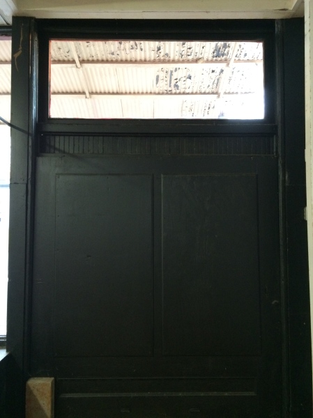
Through the front door.

img_5911

Adjacent to the school – an old freight depot perhaps?

26917217765_f02ed601e4_o

Another freight building / storage building.

26849788511_c61fbbe724_o

The entire complex is abandoned.

Internet searching revealed little, other than as of 2013, the Renaissance Plan for Fort Edward included a plan to develop the Agway Complex into a multi-use complex. Hopefully that comes to fruition.

Readers, what do you know about this Fort Edward school? I’d love to hear more.

Seasonal Buildings: Union Church in New Haven Mills

White, gable-roofed churches with tall steeples are anchors in Vermont’s villages, historically and visually. Small towns often have more than one church, speaking to a time when people attended churches and community meetings in greater numbers. In modern day Vermont, these large buildings remain in the same small villages, whose populations and budgets are fading. As you can see in Abandoned Vermont posts, some are empty, and others are used only seasonally:

Seasonal churches are used in the summer when the building does not need to be heated and lack of electricity, perhaps, is not a hindrance to use. Buildings closed up for the winters are not uncommon in the colder climates; many summer camps and cottages are winterized and sit alone for the winter months.

img_7116

Union Church of New Haven Mills, VT, built 1851.

Union Church in New Haven Mills, VT is one of the seasonal churches. For decades it was used once per summer month for a church service, and the occasional special event.

img_7121

View through the window. Front entrance to the right.

Union Church was constructed in 1851 as a church and meeting house to accommodate the growing community of New Haven Mills. Local craftsman Eastman Case constructed the building; his study of Asher Benjamin is evident in his design. Union Church is listed in the National Register of Historic Places as a well-preserved example of a wood frame Greek Revival style church with features that including the temple-front gable entrance, corner pilaster, full entablature and pediments, oversized windows, and interior details. The Queen Anne style belfry was added ca. 1880.

img_7117

Greek Revival details.

img_7118

Interior details: pews, plaster, tin ceiling.

The 20th century brought floods and fire to the community, which led to the demise of the town and its lumber industry. The church sat empty throughout the 1930s, until Burt Rolfe, a Middlebury College student, took on the role of caretaker and preacher. Mr. Rolfe died in World War II. Neighbors, Langdon and Colleen Smith began taking care of the building and holding one monthly summer service for the next 40 years. When the Smiths died, neighbors continued to maintain the building. The church survived because of the neighbors and the community’s efforts to host events, raise money, and preserve the building. (Read the project file here for additional info.)

img_7122

Through the window: failing plaster throughout the church.

The Preservation Society of the Union Church of New Haven has continued repairs as part of the long-term preservation project since the 1990s.  In 1997, the Preservation Society applied for and received a grant from the Division for Historic Preservation to stabilize the foundation and paint the building. In 2011, the Preservation Society received another grant to repair the 20/20 double hung windows.

img_7123

New roof, 20/20 windows restored. Greek Revival details: pilasters, wide frieze, cornice returns, gable temple front.

img_7126

In need of exterior maintenance.

It’s a beautiful building in a striking setting, overlooking the small village of New Haven Mills and set adjacent to the Lampson School. However, buildings are meant to used and if they stand in year-round communities with only seasonal use, there is lost potential. Keeping a building seasonal allows the greatest amount of preservation. No wiring is needed; the building needs to be maintained, but not altered or disturbed. However, in our cold climate, that limits the months. And what a shame to not be able to use this building all year round. Perhaps minimal modernization and addition of systems would be worth it in order to use the building.

img_7132

The view as you approach from East Road. To the right is the Lampson School.

img_7139

View from the Union Church, looking to the Lampson School and a farmstead.

It’s a good preservation theory discussion. What do you think? If there is use, keep the buildings as-is for the warm seasons or disturb them for year-round use?

Applying What You Know: Reading the Built Environment

Learning to read your built environment – your city – helps you to form tangible connections to where you live. In turn, your sense of place and community increases. You feel ownership and responsibility for your town or city, which allows for better planning and smart development. The longer you live somewhere and study, the better you get to know a place; the more you love it.

But what happens you go someplace new? How do you read the built environment if you know nothing about its history? Good question. The best part of learning to read the layers of the built environment is that you can gain a sense of place and understanding without needing to know its cultural history. How do you do that?  By observing and translating the elements of the built environment you see the development and changes.

Elements of the built environment include street patterns (gridded or not?), buildings (height, architectural style, materials), parking lots (where? garages?), sidewalks (width, material?), landscaping (trees?), bridges (type?), utilities (underground wires or telephone poles?), and more.

I want to share an example that I used in my recent Built Environment lecture. It’s simple, but a good place to start. Ready to play along? And, go!

Recently, I traveled through Prescott, Ontario, a town on Canada Route 2 along the St. Lawrence River. I stopped in what appeared to be the center of town. As a preservationist, I always enjoy getting out of the car and wandering for a few blocks to snap photos and observe the area, stare at buildings – that sort of thing.

Here is the view standing on the corner of Centre Street and Route 2. Note the historic building block on the right. On the left, however, is a large parking lot. Parking lots always raise an eyebrow for me – why is there a large parking lot in the center of town? Historically, towns were not built with parking lots in the middle. Let’s have a look around.

Slide1

Parking lot (left) & historic building block (right) in the center of Prescott.


Slide2

Top left: the same historic building block mentioned above. Right: tower and parking lot at the SW corner of Route 2 and Centre Street. Bottom left: The same parking lot as seen from the other end of it (note clock tower behind the tree).


You can see the photos above. Now let’s step across the street. These Google street views (below) show that SW corner (in the first photo I stood next to the clock tower).

Once I did a 360 observation of the block I had a few guesses. In the United States, if there is a hole (read: parking lot) in a town or city, I automatically think 1960s Urban Renewal era. However, this was Canada, so I wasn’t sure on Urban Renewal.

But, the drug store adjacent to the parking lot had a mid 20th century vibe (see image below). The general automobile culture (1950s/60s) often falls in line with demolition and parking lots for auto-centric businesses.

Slide3

Google Street views of the corner and drug store.

My guess? A historic building was demolished for the drug store and parking lot, and the clock tower built on the edge of the parking lot to “honor” the historic building. Classic, right? Always the preservation nerd, I did some Googling to see if I could find information about Prescott development. It took a while, but eventually I did find my answer!

Yes, there was a historic building there. This one:

Slide4

Prescott, Ontario 1876 Town Hall. The clock tower was a later addition.

According to this source, the town hall was demolished in the early 1960s due to neglect and lack of available funds in the town for repair. While I couldn’t find when the drug store was built, I have a pretty good guess that it followed shortly after demolition of the town hall.

While this was not the most uplifting example of reading the landscape, it is important to understand how our cities and towns are shaped by individual projects and decisions. And the lesson? When you see a large hole in the center, spin around and look around. It’s probably not supposed to be there.

Abandoned Quebec: Henrysburg Church

For years on my travels from Burlington to Montreal, I’ve caught glimpses of a small brick church beside the highway giving me an “abandoned” vibe. Even from the highway at 60mph, I could see that this church didn’t have any windows.

Finally, I was able to take a detour to visit this church. Getting off the exit at Henrysburg, Quebec, I was stunned. At first, there didn’t appear to be a way to get to the church, as it appeared to be encircled by the highways and ramps, without an access road. Fortunately, that was not the case. A small road off the access ramp led to the church.

A view from the side of Autoroute 15.

A view from the side of Autoroute 15.

The stone is the edge of the church property. See Autoroute 15 and the overpass. The church is practically in traffic.

The stone is the edge of the church property. See Autoroute 15 and the overpass. The church is practically in traffic.

See that island of trees? The church sits in there.

See that island of trees? The church sits in there.

Just sitting there in the middle of an interchange. (I do not know what Noel Canada means in this location.)

Just sitting there in the middle of an interchange. (I do not know what Noel Canada means in this location.)

The access road leading to the church.

The access road leading to the church (looking back to the highway on/off ramp). 

Despite the proximity to Autoroute 15, this is one of the most peaceful locations that I have visited. The church sits in an oasis of trees. The grass is mowed, probably because there is an active (as recently as 2012) cemetery on site.

Henrysburg Methodist Church, 1861.

Henrysburg Methodist Church, 1861.

Church & cemetery hiding in the trees.

Church & cemetery hiding in the trees. And, no windows on the church. 

The cemetery beside the church.

The cemetery beside the church.

Some headstones date to the mid to late 1800s.

Some headstones date to the mid to late 1800s. That’s the highway in the background. 

Others are much more recent, including up to 2012.

Others are much more recent, including up to 2012.

It's always sad to see a vandalized headstone. I wonder if this person's descendents have any idea.

It’s always sad to see a vandalized headstone. I wonder if this person’s descendents have any idea.

View on the other side.

View on the other side.

Front of the church. Note the tower is covered in vinyl. Meaning, not all that long ago, someone "cared" to take care of this church.

Front of the church. Note the tower is covered in vinyl. Meaning, not all that long ago, someone “cared” to take care of this church.

I was not expecting to find what I did when I looked in the church windows.

Rubble!

Rubble!

The interior was completely stripped of all materials - walls, floorboards, everything!

The interior was completely stripped of all materials – walls, floorboards, everything!

Upon further investigation, I found a demolition permit. It expired in 2014. Perhaps they started and were stopped?

Upon further investigation, I found a demolition permit. It expired in 2014. Perhaps they started and were stopped?

Montee Henrysburg.

The former address: 138 Montee Henrysburg.

I stood there fascinated while simultaneously feeling like I was attending a building’s funeral, or memorial service and having so many questions. Why is this church stripped of everything? How long has it been in the middle of this interchange? When was the roadway completed? Why was demolition stopped? Is there a community group, or perhaps the descendents of the departed have rallied? So many thoughts and questions. What are yours?

Presumably, the church was active until the overpass was constructed, until Autoroute 15 was widened or completed. The road was completed around the 1960s, though I cannot find a definitive date, nor one for roadway upgrades such as widening. A lot of google searching reveals only that the church was constructed as a Methodist Church in 1861 and active until 1975, but burials have continued until 2012.

And why strip the church? Perhaps to protect it from fire? It’s much harder to burn a brick building than one filled with wood and other flammable objects.

Does anyone care about this church? I cannot think of another example of a building stuck in the middle of an interchange. One on level, the interchanged caused the demise of the building. Yet, it’s also preserving this structure. It doesn’t appear to be a spot where anything else would be built, so why not leave the church there?

You can see the super-tall  highway lights over the ridgeline of this church.

You can see the super-tall highway lights over the ridgeline of this church.

Do you know anything about this church? I’d love to hear more and find out it’s fate, hopefully with good news.

Old Ruskin Church, Ware County, GA

Traveling across Highway 84 in Ware County, Georgia, you’ll see a worn sign with red lettering on the side of the road in Ruskin, an unincorporated community in Waycross.

Off Highway 84.

Off Highway 84.

Looking back down the dirt road (in front of the church).

Looking back down the dirt road and across the tracks (in front of the church).

The “Old Ruskin Church” intrigues a preservationist familiar with John Ruskin’s, The Seven Lamps of Architecture.  Pull over, make a u-turn and turn down the southern dirt road, Griffin Road. Cross the tracks at the curve in the road is the Old Ruskin Church. This darling white church sits quietly beneath the picturesque canopy of long leaf pines, among the fallen pine straw.  On a sunny day, it seemed to be one of the most serene spots to find.

Old Ruskin Church.

Old Ruskin Church.

Perfect southern setting.

Perfect southern setting.

The steeple among the pines.

The steeple among the pines.

Beautiful detail on this little church. And also many bees nests. It's in need of some maintenance.

Beautiful detail on this little church. And also many bees nests. It’s in need of some maintenance.

One more for good measure.

One more for good measure.

The Old Ruskin Church, ca. 1899, belonged to the Ruskin Commonwealth, a Utopian socialist community incorporated in 1899. This community was founded by 240 people who moved near Waycross in 1899 from the Ruskin Colony in Tennessee (1896-1899). As the name suggests, the community was founded on principles of the English social reformer John Ruskin.  See photographs of the community here. Unfortunately, the settlement lasted only a few years, disbanding in 1901 due to poor farming land, poor business ventures, disease and poverty.

Who owns this church? What goes on here? There was no indication. Do you know anything about it? Please share!

Preservation Pop Quiz: Buena Vista, GA edition

It’s been a while since there’s been a Preservation Pop Quiz around these parts. This one is from my travels in Georgia. A group of us attended a local art opening in Buena Vista, GA. The opening took place in a historic building, though the drop ceiling and other modifications hid the original details of the building. But, like the preservationist that I am, I walked around the perimeter of the big room and looked up, staring at a particular corner for a while. Why was this door here and how did it function? I do have the answer to this one, but tell me your impressions first!

First up: the exterior of the building in Buena Vista, GA.

First up: the exterior of the building in Buena Vista, GA.

Storefront of the building.

Storefront of the building.

Exterior of the particular corner that perplexed me.

Exterior of the particular corner that perplexed me.

Interior space for the art opening. Note the fluorescent lights and drop ceiling.

Interior space for the art opening. Note the fluorescent lights and drop ceiling. Corner in question is on the right.

The interior corner, a door.

The interior corner, a door.

Bottom of the door.

Bottom of the door.

Looking up above the door.

Looking up above the door.

Looking up in the same area.

Looking up in the same area.

You can see the door, then the transom, then the ceiling.

You can see the door, then the transom, then the ceiling.

And another interesting feature of this building. Vents beneath the sidewalk.

And another interesting feature of this building. Vents beneath the sidewalk. (Unrelated to the quiz question.)

What do you think?

A Visit to Wilmington

If you’re a preservationist in Vermont, you know Wilmington for the 2012 Historic Preservation and Downtown conference and the 2011 flooding of Tropical Storm Irene, among other reasons. If you’re an out-of-stater, you probably know Wilmington as a ski town; Mount Snow is just up the road. And maybe you’ve all heard about Dot’s Restaurant (The NY Times reported on its reopening last December). Wilmington is a beautiful small town in southern Vermont with a good stock of architecture, amenities for visitors and pleasant streets. Take a look (side note: click on the photographs to enlarge, and see them with better clarity). 

Wilmington is currently filled with giant chairs.

Wilmington is currently filled with giant chairs.

Ascending front gables on South Main Street.

Ascending front gables on South Main Street.

The 1898 Crafts Inn.

The 1898 Crafts Inn.

Route 9 & Route 100. Check out those brackets!

Route 9 & Route 100. Check out those brackets!

This building is undergoing renovations (still, post flood). It is the 1930 Parmalee & Howe Drugstore.

This building is undergoing renovations (still, post flood). It is the 1930 Parmalee & Howe Drugstore.

The intersection of Route 9 and Route 100 features a beautiful pocket park.

The intersection of Route 9 and Route 100 features a beautiful pocket park.

Looking for more history? Read the entire National Register nomination here. It’s now available online thanks to the massive digitization effort by Vermont Division for Historic Preservation (our SHPO office). And it’s almost leaf peeping season, followed by ski season. Enjoy Vermont if you’re coming for a visit!

Abandoned Vermont: Reading House

Over the years, I’ve driven past this house many times getting that “abandoned” vibe from it, then noticing broken windows, overgrown brush, yet a mowed lawn. Maybe it wasn’t entirely abandoned, but certainly no one lived in this house. Finally I stopped to take some photographs. Considering how long it’s been neglected and vacant, it is in good condition. Who needs a house in Reading, Vermont? Advice for when you cannot information about a property (e.g. if it’s for sale): call the town offices.

Surrounded by trees.

Surrounded by trees.

The side of the house.

The side of the house.

The rear of the house is a bit more worn. But the slate roof is gorgeous.

The rear of the house is a bit more worn. But the slate roof is gorgeous.

The porch has seen better days, and this rear ell.

The porch has seen better days, and this rear ell.

Beautiful back porch (you probably remember this photo from an Instagram post).

Beautiful back porch (you probably remember this photo from an Instagram post).

The interior is not too far gone.

The interior is not too far gone.

Seen through the back door, not in such great shape.

Seen through the back door, not in such great shape.

But it might need some plaster. This Rutland Patching Plaster is from nearby Rutland, VT!

But it might need some plaster. This Rutland Patching Plaster is from nearby Rutland, VT!

Beautiful doorknobs!

Beautiful doorknobs!

Barn view from the porch.

Barn view from the porch.

Front of the barn.

Front of the barn.

The front of the house is hard to see from the road, as the road sits further behind this photographer.

The front of the house is hard to see from the road, as the road sits further behind this photographer.

What a beautiful property, isn’t it? It hasn’t been surveyed (that I can find), and is not listed in the State or National Register. However, I’m sure you could make a strong case for eligibility in Reading, VT. What do you love most: original windows, hardwood, wood details, doorknobs, slate roof?