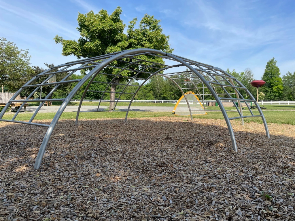
It’s summertime! I have a few new (to me) playground apparatus finds, and it seems like the perfect season to share them. You never know where a vintage piece of playground equipment will be. I was surprised to come across this one, sitting adjacent to a large modern playground in Williston, VT.
Today’s apparatus feature is the 1975 Miracle Recreation Equipment Company’s “Four-Way Climber”.
From the book Once Upon a Playground: A Celebration of Classic American Playgrounds, 1920-1975 by Brenda Biondo (University Press of New England, 2014), page 88. The advertisement reads “Boys and girls love the patented Four-Way climber because it can take on a whole group of children at one time. They can climb, balance, chin, leg drop, or skin the cat with plenty of room to maneuver on this sturdy climber.”
For those wondering what “skin the cat” means in the advertisement above… I looked it up, too. It’s a gymnastics exercise and involves starting in a dead hang, keeping your arms legs straight, pointing your toes, and bringing your legs over your head into an inverted hang position.
These 1970s pieces are getting rarer as the years tick by, so take photographs while you can and send them my way. I’d love to feature them on Preservation in Pink.
Happy New Year, friends! I hope 2021 brings you good health, happiness, prosperity, and may it bring peace as well. I think a good way to start 2021 on Preservation in Pink is with a fun playground post. This is the one I referred to as “waiting in the wings.” I hope you enjoy it. Thanks for sticking around, preservationists and friends.
Last winter, I wrote about a playground in Brownington, Vermont. On the playground, I found a mysterious piece of playground equipment – one that was new and unusual to me. Internet searching led me to find identical pieces, but no information about it. Readers and Instagram followers assumed what I did – a space age era piece of playground equipment, but nothing definitive.
Fortunately, an Instagram acquaintance (@followthebreadcrumbs2) gave me some information about this apparatus. She said that she was fairly certain it was designed by David Aaron and manufactured by Alcoa (Aluminum Company of America) in the 1950s. A quick search using that information and she was right. That was exactly the information I needed, and it made my day (yes, yes, I’m a playground nerd).
Found in Brownington, VT. Space Age Playground at Sterling Forest Gardens, Tuxedo, NY.
Historically, playground equipment was made of steel. Aluminum had been widely used during the war years as a component in airplane manufacture. As part of its strategy to win new markets after the end of Word War II, Alcoa tried to catch the interest of the design community and make the consumer comfortable with this material (source: http://architekturfuerkinder.ch/david-aaron/). This effort was known as the “Forecast Program”. For this venture Alcoa focused on the designer as ‘the man to stimulate the consuming public with inventive projects for the home”, and invited a range of designers including Isamu Noguchi, Alexander Girard, Charles and Ray Eames and many others to participate, including David Aaron. What Alcoa wanted from the designers was not a product to manufacture, but a concept to promote.
“With the new Forecast design, aluminum is given its first serious introduction into outdoor playground applications. The lightweight, rust-proof characteristics of the metal, – plus its ability to be colored, make it a maintenance-free, “natural” for playground use. The climbing tree is scheduled for actual production by Creative Playthings, Inc., New York City.” The “tree,” other Forecast items, and products of Massena Operations of Alcoa was on display during “Aluminum Days” of the Massena (NY) Vacationland Festival (1958).”
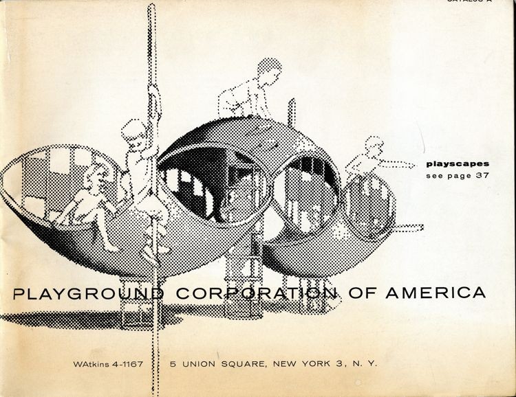
Additionally, David Aaron was the Director of the Playground Corporation of America. Mr. Aaron designed these midcentury pieces called “play shell-ters” with 13 designs for ages 18 months to 13 years, according to the 1959 Playground Corporation of America Catalog.
The September/October 1965 Playground Corporation of America information booklet titled “Park Practice Grist” discusses new concepts in playgrounds, specifically some that allow children to play independently, energetically, even with short attention spans, while growing and learning confidence. Playgrounds were designed to stir the imagination; each playground apparatus could be whatever a child imagined. And because equipment was stationary (unlike swings or merry-go-rounds), it was thought to be safe. The booklet describes “shell-ters” as:
Dome-shaped shells of cast aluminum are caves, ships, playhouses, crows’ nest, forts…whatever busy young imaginations proclaim them to be. They can be installed concavely or convexly or upended to form curved walls. They are used in a variety of ways in combination with sliding poles and/or with such climbing apparatus as cylindrical “ring dings’ and grill like “wing-dings’. These versatile shapes are made of non-corrosive aluminum, require no maintenance.
David Aaron, a designer of playgrounds, died of a heart attack Tuesday at his home in Accord, N.Y. He was 60 years old. Mr. Aaron was the founder of the Mid-Hudson Institute of Community Design for the Young in Poughkeepsie, with which he was associated at the time of his death. Among his creations were the playground for the United States pavilion at the Moscow Fair in 1959, the Playground of Tomorrow at the 1964-65 World’s Fair in New York and the playground at an elementary school in Bronxville, N.Y. He is survived by his wife, Maia; two sons, Peter, of Brooklyn, and Michael, of Chicago; a brother, Howard, of Bridgeport, Conn., and one grandchild.
Thank you to David Aaron for your devotion to playgrounds and creative play.
This was much more information than I was expecting to find about a single playground apparatus. I still don’t know why a single piece of playground apparatus was placed behind a church in Brownington, VT. Perhaps something second-hand from a school or a town park? Or one piece specifically purchased for the church? If anyone knows, I’d be thrilled to learn.
Theories of play and playground equipment come and go like all trends; it is interesting to find historic playground equipment – usually on private property or in rural areas. Have you seen any of these pieces at playgrounds?
More than not, I have steered clear of politics on this blog. But the November 3, 2020 election is too important. The last four years do not represent the majority of the United States. The sitting president does not deserve the job. He does not care about you or your family. He lies all day long, every day. He is an embarrassment to the United States and gets joy from bringing out the worst in society. Maybe some people’s wallets are thicker than four years ago (some, but not most), but this is about human decency. This not Republican v. Democrat. This is Trump v. Not Trump. This is wrong v. right.
Be better, fellow Americans. We are better than Trump. We deserve better. We have a choice.
Your vote matters. Your vote counts. Plan ahead. Be prepared. Vote. Vote Trump out. See above. There is only way to do so. This is not the time to vote third party. Vote for Joe Biden. He is an honest man, a decent human being, intelligent, and a leader.
2020. It’s been quite the year so far. I’m not sure where to pick up since it’s been a while. It feels like 2019 was a lifetime ago. To think that I thought moving into a fixer upper house and having baby #2 would be the big headlines of the year.
How unique is it to know that we are living through a significant chapter of history? It is a lot to process. A pandemic. Racial unrest. Hopefully a positive turning point in the work to erase racism in our country. Important change. Perhaps the most important election of all time. And on top of everything, we all still need to manage our day to day lives, selves, jobs, households, children, etc. Nothing worth having comes easy, so the saying goes. At times it can be exhausting, heartbreaking, sad, and every emotion. Hopefully you are able to find time to rest, recharge, and connect with loved ones, even if only digitally.
Preservation in Pink is still here. I’ve stepped back – clearly – to manage work, home, life, but I’m grateful to those of you who still visit and find value in Preservation in Pink. I’ll post as I’m able. I have a playground post waiting in the wings.
In the meantime, I hope you are well. I wish you good health, happiness, safety, and sanity. Please know ALL are welcome here. EVERYONE is important to our shared heritage.
I urge you to be kind. And please vote. Make sure you register to vote in time. It is your right as an American citizen! Make your vote count. Vote early. Request a mail in ballot if you can. Drop it off if you can. Find your state rules here: https://www.vote.org/voter-registration-rules/ .
Brownington, Vermont is located in the Vermont’s “Northeast Kingdom” (Essex, Orleans, and Caledonia counties), about 15 miles south of the Canadian border. It’s a very rural, picturesque part of the state. I was surveying a few properties in Brownington, VT for a work project and wanted to snap a photo of the church in Brownington Center.
Brownington Center Church, 1854.
Brownington Center Church, 1854.
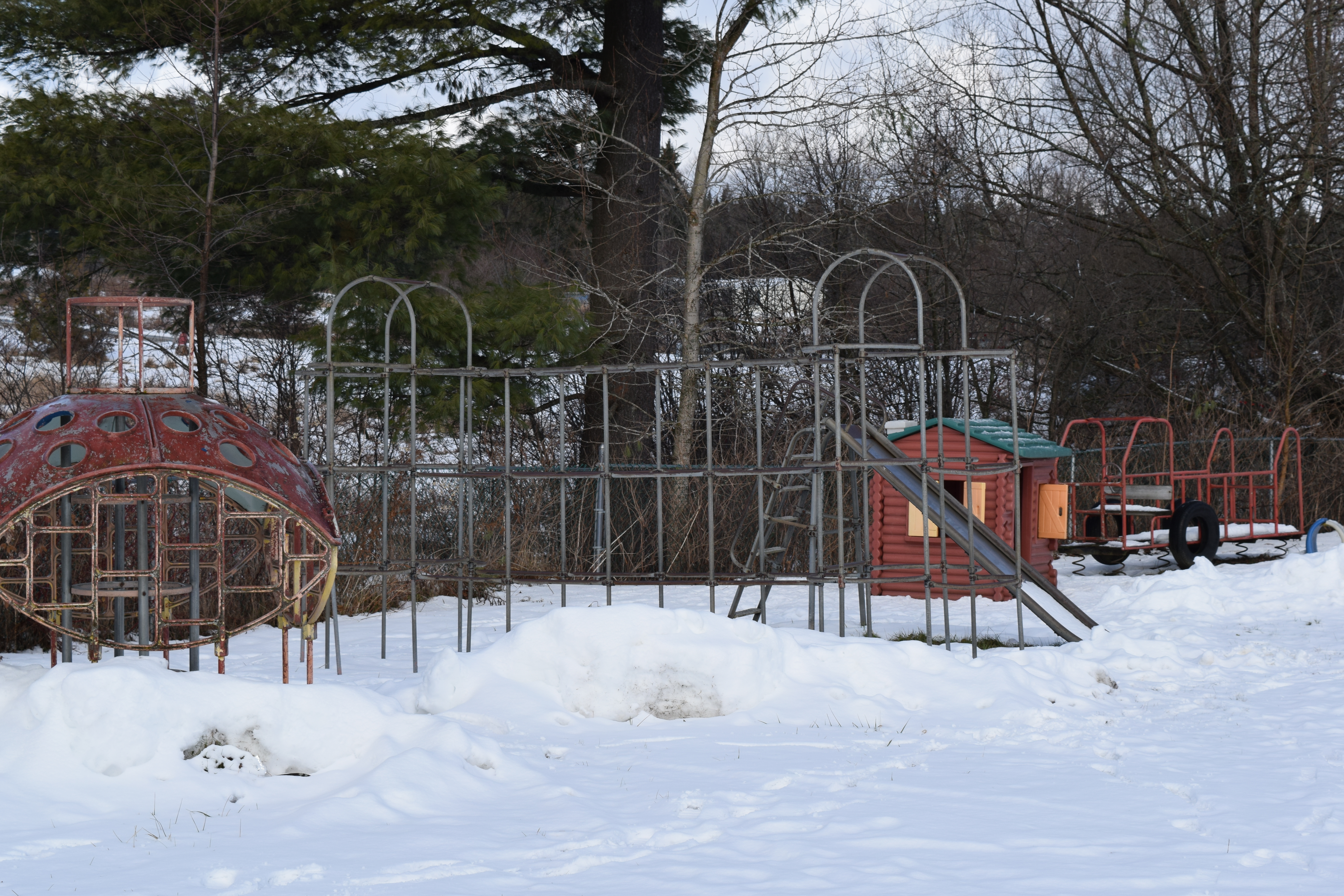
Distracted by the building, I almost missed this gem behind it!
Vintage playground equipment sitting behind the Brownington Center Church!
Of course, I got out of the car to get a closer look at the playground equipment. First up – a classic 1950s jungle gym (see photos below). The American Playground Device Company (now the American Playground Company) produced similar looking jungle gyms in the 1950s. An easy way to distinguish earlier jungle gyms from 1950s jungle gyms is the rounded elements of the 1950s jungle gyms as opposed to the non-rounded and overall square structures of earlier versions. This jungle gym has “ST. JOHNSBURY, VT” stamped on one of its pipes. St. Johnsbury, is a larger town about 36 miles away from Brownington. Perhaps this was a hand-me-down piece?
Next up, the slide. Slides are a little harder to date, but based on the design, it appears to be another 1950s apparatus.
This slide is sinking into the ground.
Recreation Equipment Corp. Anderson, Indiana. 10-A. (Does anyone know what the 10-A represents?)
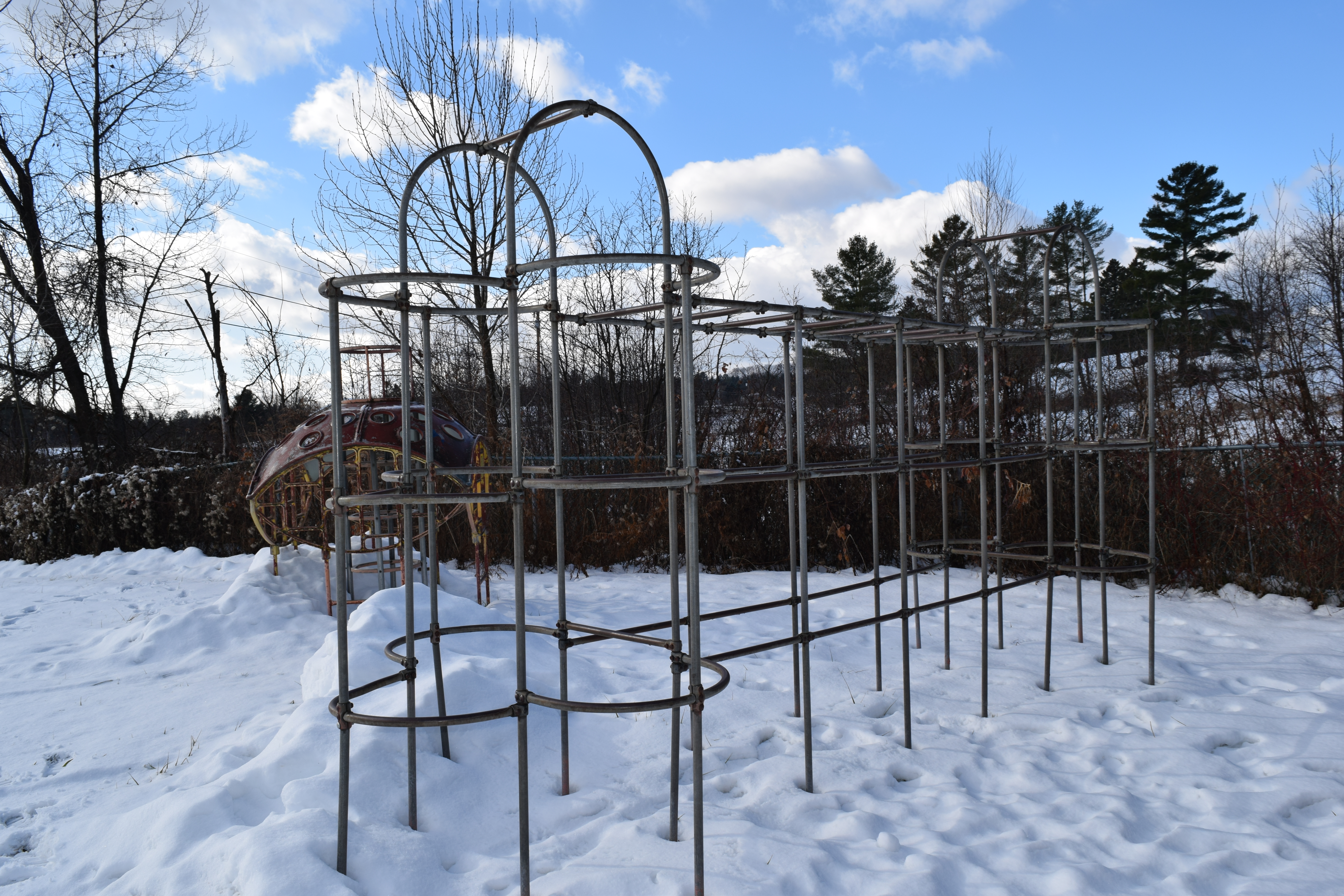
Next up: the mystery apparatus. I don’t even know what to call this one. It dates to the 1960s space age era of playground equipment, but nowhere can I find a name for it or a specific manufacturer. It’s part spaceship, part jungle gym, part submarine, part ladybug? Take your best guess. Do you recall playing on something like this?
I’ve found a few similar images while searching online, but no luck with names. Do any of these ring a bell? Sources are in the photo captions. Click on each image or on the following links (clockwise, starting at top left): Photo 1, Photo 2, Photo 3, Photo 4. Any help in giving these a name or manufacturer would be much appreciated!
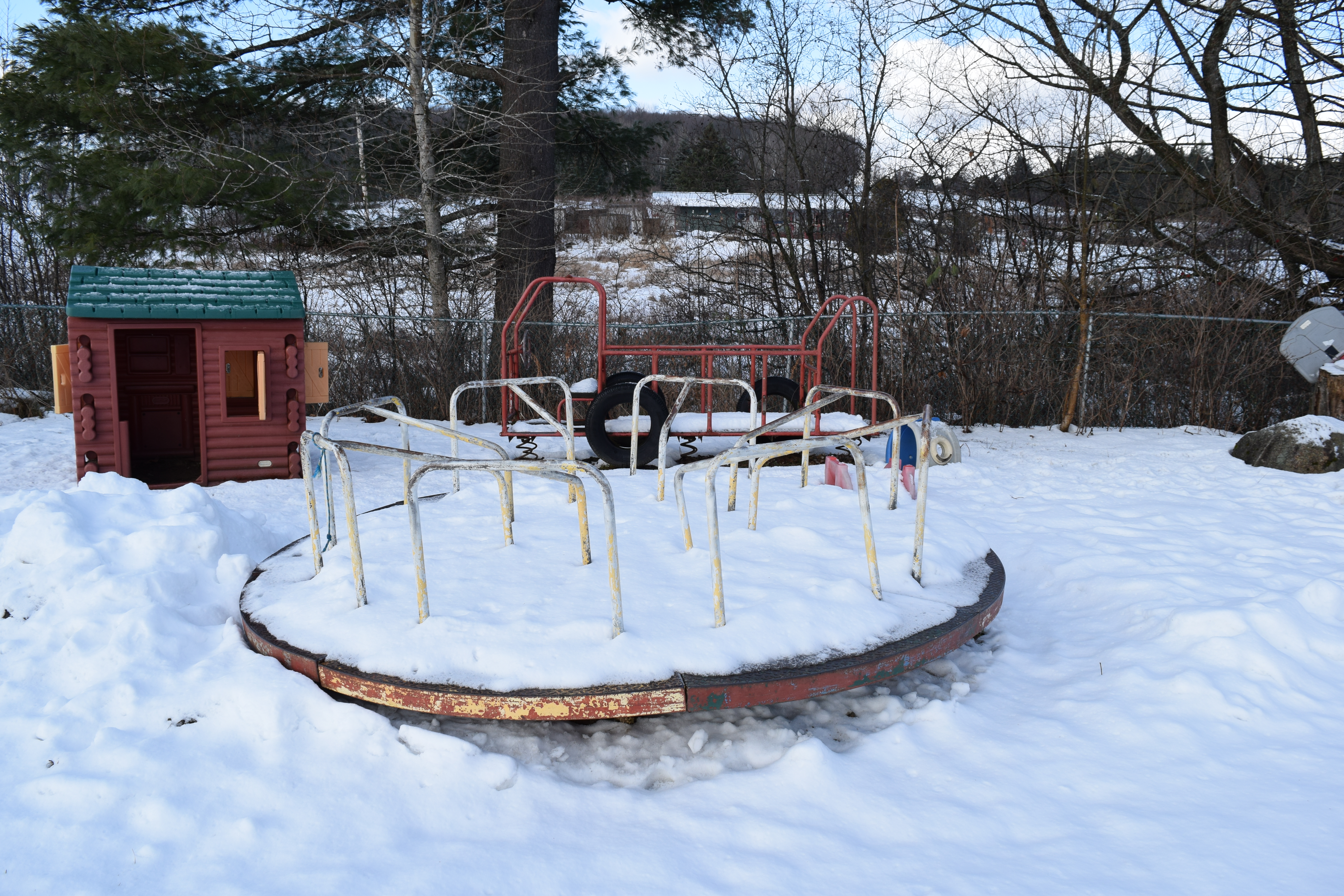
And what is an old playground without a merry-go-round? This is a later version, likely the 1970s, which you can tell by the shape of the handles and the pattern of the metal treads. It still spins – I checked!
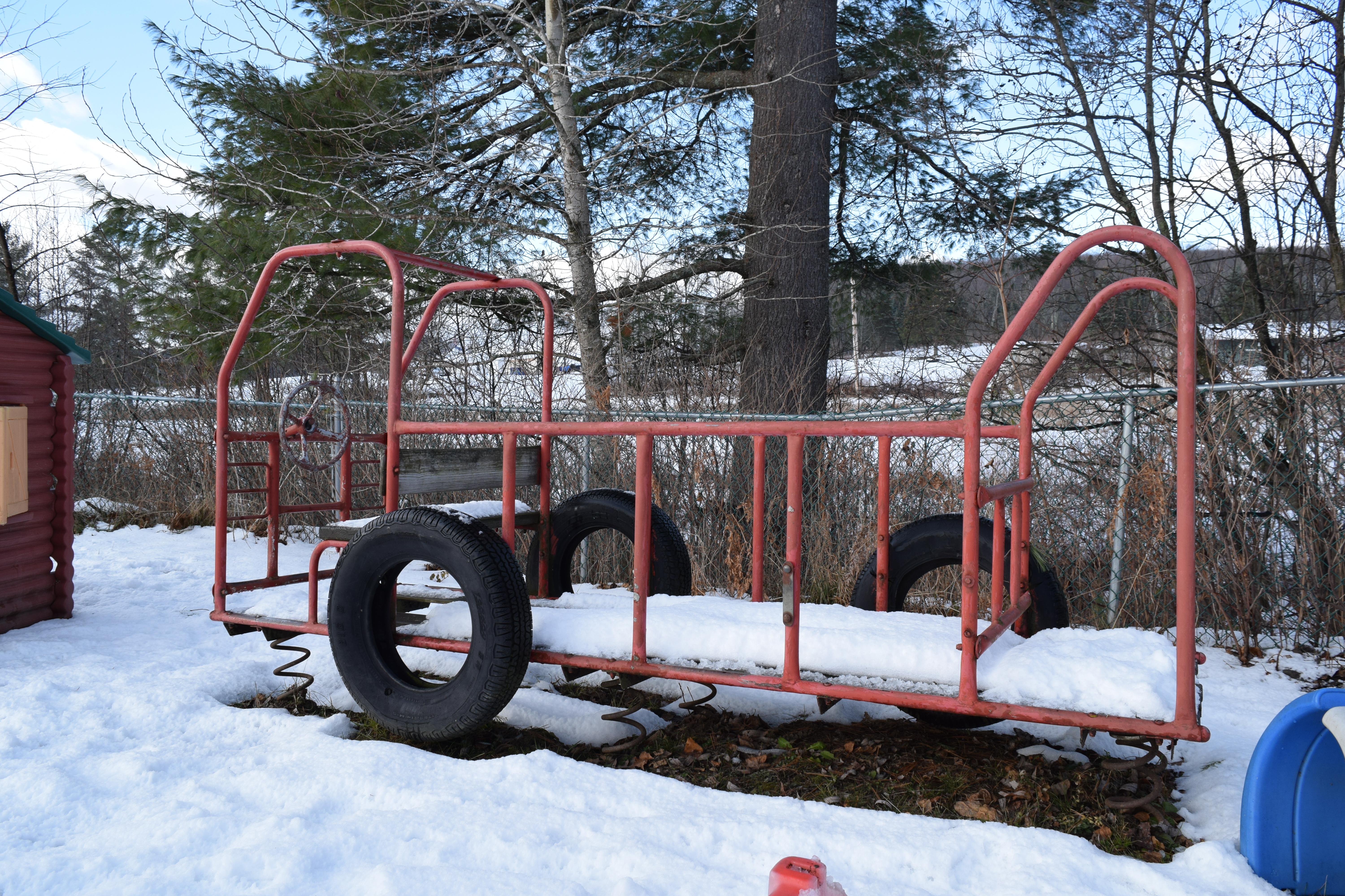
Behind the merry-go-ground is an assuming fire truck. These types of play structures were common in the 1970s as well.
And that concludes the tour of the Brownington Center Church playground: pieces from the 1950s – the present (note the plastic playground pieces I did not feature). I hope kids are still enjoying these pieces.