Addison Town Hall Open House – September 14

addison town hall

At long last, good news about one of my favorite buildings – the Addison Town Hall at the junction of VT Route 22A and VT Route 17 in Addison, VT. I’ve loved this building since my days of driving to Chimney Point during the Lake Champlain Bridge construction project and my days of conducting a conditions assessment on the Addison Town Hall in graduate school. When a local architect emailed me to let know that community is interested in the Town Hall again and has a plan for rehabilitation, it made my day.

The Open House will let people know about the proposed plan in preparation for the bond vote on September 24. This bond is for the wastewater project, the necessary precursor to the rehabilitation project. More information to follow! I hope you can stop by the open house this Saturday September 14, 10am-2pm.

Past Addison Town Hall posts:

Playground Find: Hancock, VT

Hancock, VT is a small town (population 323) located on Vermont Route 100 in Addison County, on the eastern edge of the Green Mountain National Forest. The two-room Hancock Village School was constructed in 1855 and operated as a school until 2009, when school consolidation measures caused the school to close. Since then the building has served as the town library and the town clerk’s office. The school is a contributing resource to the Hancock Village Historic District, which is listed in the Vermont State Register of Historic Places (VHSSS #0108-1-20). A playground remains on the former school grounds.

hancock school

Hancock Village School, December 1976 – Vermont State Register of Historic Places.

img_0532

Former Hancock Village School (now library and town offices), June 2019. The windows have been replaced.

img_0520

Swings with mountains and blue sky in the background.

img_0524

View of the jungle gym and the swings.

img_0525

The school in the background.

img_0526

A newer, plastic side is in on the left. 

img_0531

The apparatus is reminiscent of the “Muscle Man” equipment from the 1970s. 

img_0522

From the jungle gym: “Quality Industries, Hillsdale, Mich. 200028”

img_0530-1

No markings visible on the swings, but likely they date to the same time or earlier as the jungle gym.

img_0527

Swings.

The jungle gym bears the stamp, “Quality Industries, Hillsdale, Mich., 200028.” Quality Industries began in 1974, and the named changed to Recreation Creations, Inc. (RCI) in 1996. The name changed to Recreation Creations, Inc. in 1996. Without more available information, it is difficult to date this date playground equipment. However, it is reminiscent of similar 1970s playground apparatus, such as the Game Time Muscle Man. The edges appear more rounded than the example linked, possibly indicating the Hancock playground is a later design. If you have a better idea of the manufacture date, let me know. The swings did not have any markings on them.

It’s a shame that the building and the grounds no longer serve as a school, but at least the playground remains; what a picturesque spot for a playground.

Brutalism at IKEA

I’m a preservationist, but I live in a small condo, in a new building in Vermont. This sounds opposite of a what a preservationist would choose, right? Well, sort of. While the building was constructed in 2014, it was constructed on a parking lot in downtown Burlington. I can walk everywhere and choose to use the car as minimally as possible, embracing an urban lifestyle and shopping local when feasible. Because my condo is small, I have come to embrace IKEA design. It’s minimal, modern, streamlined, and perfect for small space living. I can spot an IKEA piece from across a room or from a glimpse at a photograph and know what is worth buying and what isn’t. Anyone with me?

Recently, I visited IKEA New Haven (CT). I’ve blogged about this IKEA before. It’s the one that sits next to the (now IKEA owned) former Pirelli Tire Building, a 1968 building designed by Marcel Breuer in the Brutalist style. IKEA demolished the two-story wing, but the main block remains. Not the best preservation story.

During my recent visit, I peaked in the windows of the building. It’s still empty. However, news reports say that IKEA is considering rehabilitating the building into a hotel. It’s just a rumor, it seems, but it sounds promising, and maybe would serve as (belated) mitigation for the adverse effects to the building. It would make IKEA a destination, for sure. Ha.

img_2957

View from the IKEA cafeteria. 

img_2955

Reflected in IKEA. 

img_2951

Exterior details. 

img_2952

Looking up.

img_2950

Peeking inside the bottom floor of the Pirelli Tire building.

img_2960

Sitting in the IKEA cafeteria, you can gaze upon the Brutalist architecture. 

What do you think? Do you appreciate Brutalism more as time goes on? Do you love IKEA or steer clear? And where do you live? Urban? Suburban? Rural? New? Historic?

Brookside Cemetery, Chester

‘Tis the season for cemeteries, foliage, and foggy days. Brookside Cemetery sits in the center of Chester, a picture perfect town in southern Vermont. It is a historic, intact, linear later 18th century to early 20th century Vermont village. The cemetery is located between the Chester Historical Society (the ca. 1881 brick schoolhouse) and the 1835 Baptist Church. Across the street is the town green and on the other side of the green is a beautiful, intact row of a historic buildings. Brookside Cemetery has been in use since the 18th century; the earliest headstone dates to 1770. In New England tradition, the burials face east and the stone lettering faces west. Even on a gloomy fall day, it’s peaceful. Take a look!

img_2771

Looking to the schoolhouse and the cemetery.

img_2779

View to the Chester Historical Society. 

img_2790

Headstones.

img_2785

img_2777

The main entrance to the cemetery; this fence dates to 1867.

img_2776

The 1850 Public Tomb was constructed of granite block cut in nearby Gassetts, VT and transported by train to Chester Depot.

img_2774

The 1830 Hearse House is a museum as of 2017.

img_2780

The main entrance road is lined with cedar trees. The road was laid down and the trees were planted in 1867, inspired by the Mount Auburn (MA) Cemetery and the rural garden cemetery movement.


Interested in learning more about Chester?

  • Read more about Chester’s Brookside Cemetery here.
  • Read the Chester Village Historic District National Register nomination here.


Tourist Cabins: West Shore Cabins, North Hero, VT

Summer is winding down, but fall in Vermont is a perfect time of year to visit. The humidity has decreased, the leaves are changing, and you can readily find apple cider doughnuts to go with your craft beer. Take a drive on U.S. Route 2 and you’ll pass through the Champlain Islands (or “the Islands”). The Champlain Islands offer a completely different feel than central Vermont. The land is flatter, mountains are in the distance, the lake is visible for much your drive, and fall arrives a bit later than in the mountain towns. It would be a lovely time of year to stay in a tourist cabin on Lake Champlain. I’m happy to report that there are more tourist cabins operating in Vermont!

The West Shore Cabins are operating tourist cabins located adjacent to Lake Champlain on U.S. Route 2 in North Hero, part of the area known as the Champlain Islands. What began as the West Shore Inn in 1927, became the West Shore Cabins in 1945. At that time it was run by the Donaldson family who saw how a motor court would be a good economic venture as automobile traffic increased in the mid-20th century.  Some cabins were relocated to this site and others were constructed on site. Today the family operated business offers five cabins for daily or weekly rentals from May – mid October.

West-Shore-Cabins-History-Pic-3

West Shore Inn postcard. Image via West Shore Cabins.

DSC_0560

The vintage sign between the lake and U.S. Route 2.

DSC_0561

West Shore Cabins sit on U.S. Route 2 with a clear west view to Lake Champlain and its sunsets.

DSC_0554

The cabins retain much of their historic integrity including siding, porches, windows, and fenestration.

DSC_0552

Novelty siding, exposed rafter tails, screened porch and a barbecue out front; Cabin 5 is adorable.

DSC_0551

Cabins 4 and 5.

DSC_0548

Cabin 1.

DSC_0553

DSC_0547

The cabins are set back from the road, with no obstructions to the lake views.

DSC_0549

Ca. 1880 (with later alterations) residence associated with the owners of West Shore Cabins.

Happy end of summer! Let me know if you find more tourist cabins and/or stay in one!

Demolished New York: Massena High School {or: How to Answer “What Used to Be Here?”}

Demolished? It’s a variant on “Abandoned” posts, yes. However; it seems like a good way to show you the mind of a traveling preservation (or at least how mine works). What does a preservationist think about when traveling? And how does a preservationist find the answer to her question? I’ll use Massena, NY as an example, which I visited earlier this summer.

Massena, NY is a town located on the St. Lawrence River in northern New York, just south of the Canadian border. Once economically supported by the railroad and a canal, the car manufacturer, GM, along with Reynolds and Alcoa, Massena has seen better days since GM closed in 2009, removing billions of dollars from the local economy. However, the town has a good stock of historic buildings with tree-lined side streets showing its former prosperity and its potential. We enjoyed walking around town studying its current state and wondering about its past.

img_1335

Downtown Massena: underground utilities, sidewalk pavers, trees, storefronts – it is clear that there has been investment in this town not too long ago.

img_1331

The 1918 Strand Theater on Main Street is currently closed, but rehabilitation efforts are in the works.

img_1333

Theater plans in the window.

img_1332

Massena Downtown Theatre Association – see here http://massenadowntowntheatre.com/

The remainder of the small downtown “main street” includes abandoned buildings (such as the School of Business), building under rehabilitation, empty storefronts, occupied storefronts, a hotel, a post office, and some stores.

img_1336

This corner building holds a gym on the first floor.

img_1339

The rehabilitated bridge over the Grass River.

Outside of the downtown block are tree-lined residential streets with sidewalks and historic houses with front porches. There is a large park between Clark Street and Danforth Street (see map below) with a monument in it. It’s part sign, part monument, you could say.

massena park aerial

img_1325

Massena High School sign and school bell installed in the park.

img_1326

Memorial sign.

img_1327

The park and former school grounds as they appear today. The sign is behind me in this photograph.

I wondered what this sign was doing here, oddly located, in the middle of an empty park with nothing else. Where did it come from? A quick look on the map showed it labeled as “Wooden Park.” Other maps showed it as “Old Bridges Avenue Junior High School.” It seems like an odd spot for a school building, as the lot is fairly narrow. There certainly was no parking. What did it look like, if it was a school? When I have a question like this, I turn to historicaerials.com, which usually answers my question. See below. The school filled the entire space between the streets.

massena high school

The school is in the center of the photograph with Clark Street on the left and Danforth Street on the right. Note the courtyard in the middle of the school.  Photo: historicaerials.com

massena1976

Massena, 1976.

And, of course, I search for images on Google or Cardcow.com or eBay. In this case I searched for old “Massena High School” NY. I vary the quotation marks until I find what I’m looking for. When you have a common phrase such as “high school” it’s best to use it in quotes with its name, otherwise you’ll have an endless list of search results. Fortunately, this search wasn’t too difficult.

High School Massena, NY

Massena High School. Source: cardcow.com

massena high shcool photo

Massena High School (later Junior High School). Source: http://www.topix.com/album/detail/massena-ny/R3V9PSPSATQBVQOU. Thank you, kind strangers, who post information about your hometowns on the internet.

The high school was closed after the 1980-81 school year and demolished in 1986. I was unsuccessful in discovering why it was removed, but I would guess it had to do with expensive upgrades and maintenance issues. In its place a wooden park was constructed in 1990 and removed in 2015. It was officially known as the Danforth Place Creative Playground. Walking across the grass, you can still find wood remnants of the playground. The playground was removed due to deterioration and increasing vandalism and illegal activity on the playground.

And that, my preservation friends, is a simple way to find out answers to “what used to be here?” What tricks do you have?

Rare Playground Find: Miracle/Jamison 1975 Mark IV Imagine City

Playgrounds from the 1970s are almost extinct, at least the interesting (read: fun) equipment. Finding one in the wild is a treat and a scavenger hunt. By pure luck, while driving south on I-95 in Virginia, I caught a glimpse of what looked like a playground. I saw a metal spaceship-looking apparatus, which I assumed was a playground – or a carnival ride. Unable to switch lanes and get off at the exit, I made a mental note of the mile marker so I could search later.

Since I could knew it could be seen from the interstate, I traveled up and down I-95 on Google Earth until I spotted what looked like the spaceship playground (how I described it in my head). With the help of Google Street View, I found it! I was pretty certain I knew the manufacturer of the playground at this point (because I am a nerd and spend lots of time studying historic playgrounds). Fortunately, I had the return trip to look forward to so we could stop and check out this playground.

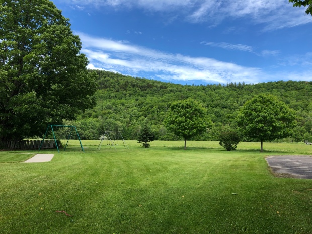
The playground is set between the interstate and a questionable motel that appears half operating, half closed. The restaurant on the property is closed and any reviews you read of the hotel are terrible. To get to the playground, you have to drive around to the back of the hotel.

This is what I expected to find (bottom right):

Miraclecatalog1974

Parks & Recreation August 1974. Source: Nels Olsen, Flickr (username: nels_P_Olsen).

And this is what I found:

IMG_4483

Playground view from the parking lot (June 2018).

It matches! I’m not ashamed to say that my excitement rivaled that of my childhood self. And if it weren’t 100 degrees outside, I would have slid down the slides and tested out the swings. Those old playgrounds can burn in the hot summer sun, as most of you probably know. Alas, I had to settle for climbing to the top and taking photographs.

IMG_4479

Miracle/Jamison ca. 1975 playground, Mark IV Imagine City model.

Take a look at the advertisement images below. You can see that the playground is indeed the Miracle/Jamison model, and there are slight differences in the configurations displayed. This playground has the central tower (center), 2-deck satellite tower (left), the tornado slide (right), a large wave slide (left) and a small wave slide (center), among the elements.

too-high-too-fast-too-fun-how-america-destroyed-the-epic-playgroundsand-how-we-can-build-them-back-up-33-638

Source, Bill Jensen: https://www.slideshare.net/billyjensen1/too-high-too-fast-too-fun. Bill has an entire slideshow about playground evolution. Check it out. However, this is Miracle, not Game Time, Inc.

1975closeup

Source: Parks & Recreation Journal, April 1975, page 3.  Miracle & Jamison ad. See full page below.

miracle_parksrec1975catalog

Found on Nels_p_Olsen flickr: https://flic.kr/p/7xQhkH

I’ve never seen such an elaborate, metal playground. How does this playground exist in 2018? Most have been removed in the 1990s for safety reasons and CPSC regulations, and because of lawsuits (including this 1985 lawsuit that required all tornado slides be removed). I assume that because this is on private property (hotel property) it has seen less use than a public playground and it is not in the most accessible location, and it seems structurally sound, so no one is forcing the owners to remove it. I hope it stays around for a while. Now, how about a tour of the playground, and some historical context?

IMG_4482

The playground is not maintained, as you can tell by the high grass.

IMG_4467

Wave slide in the center.

If the playground says “spaceship” to you, then you’re thinking in the right mindset. Playground equipment of the 1960s-70s had a space theme to it. Think of it in American historical context: the era of NASA, the Space Age, the moon landing, adventure, the unknown. Consider Googie architecture (mid-century design influenced by the Space Age) and the famous LAX airport theme building, resembling a flying saucer landing on its legs. Doesn’t this playground remind you of the terminal?

Playground equipment followed suit for architecture and societal interests. The names of equipment included radar screens, satellites, rockets, lunar lander, space cruiser, geodesic dome, and others. When you think about playground design it that way, it’s easy to spot playgrounds from the 1960s and 1970s. It’s another example as to how our built environment tells our history.

Now, back to the playground tour:

IMG_4464

View from above.

IMG_4462

View to the lowest platform.

IMG_4458

Looking down: You can also climb up the central satellite tower to get to the highest platform.

IMG_4456

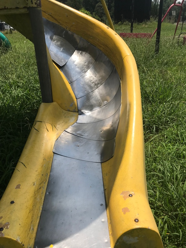
The tornado slide. I’ll admit, this slide looks painful in the hot sun (maybe even dangerous).

IMG_4469

The 2-deck satellite tower. You can climb ladders (through the circles to platforms) to move up this tower and access the slide or move to other sections of the playground.

IMG_4461

View from the platform.

IMG_4466

Stair details.

IMG_4473

It looks like a slide used to be here.


IMG_4449

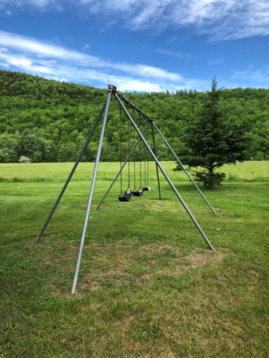
Not only did this playground have a Mark IV Imagine City, but it also had swings and other apparatus.

IMG_4481

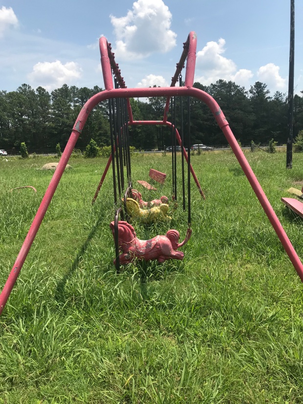
Flying Pony Swings. I looked for a stamp on these pieces to identify the company, but no luck.

IMG_4471

Spring rider.

IMG_4453

Concrete creature hiding in the grass, commonly seen in the 1960s.

IMG_1134

This playground even has a basketball court with a low-hoop, clearly for the little kids.

IMG_1138

Some sort of shuffleboard/mini golf course next to the playground.

Have you seen a playground like this recently? Do you remember playing on one of these playgrounds?  Enjoy, and keep your eyes out for playgrounds, big or small. In the meantime, if you’re in need of an internet rabbit hole, check out these advertisements from Miracle Equipment company.

Tourist Cabins: Injunjoe Court, West Danville, VT

After eight years of driving by these tourist cabins on Joe’s Pond in West Danville, VT, I finally stopped to snap a few photographs. I figured if I waited any longer, I’d be tempting fate. This collection of tourist cabins is known as “Injunjoe Court”. No, it’s certainly not a name that would be given today. However, it is reportedly named after a St. Francis Indian of the Canadian Coosuck tribe. This site was used for summer hunting grounds, and Old Joe was a scout and guide on the side of the Americans in the Revolutionary War. He protected the builders of the nearby Bailey-Hazen Road. (Source: Vermont Hsitoric Sites and Structures Survey, page 70 of this PDF.)

DSC_0172

You will see this sign on your right as you travel eastbound on US Route 2 through West Danville, VT.

DSC_0180

View from the Joe’s Pond side of the road.

DSC_0174

There are 15 cabins on the property, all slightly different and of varying sizes. Most have novelty siding and a small porch.

DSC_0175

Exposed rafter tails, old screen doors, lots of charm.

DSC_0179

The office sits up on the hill.

DSC_0185

View from the office and upper cabins.

DSC_0187

This one has an original window (2nd from left) and fieldstone chimney. Note the window flowerbox, too.

DSC_0186

A row of cabins.

DSC_0188

Spectacular views from all of the cabins.

DSC_0173

Even the cabins closest to the road offer privacy.

injunjoe

An undated postcard. Note the signage. It appears that today’s sign is the same, except for the color and the headdress removed on the left side.

Scroll to Book III, page 70 of this PDF of the Danville Vermont Historic Sites & Structures Survey for a detailed history and architectural description.

Pages from Danville_HistoricSurvey__SurveyForm_00000010

From the VHSSS, an undated postcard. The cabin at the road and the entrance gate are no longer extant.

Likely constructed in the earlier decades of the 20th century, the cabins and cottages appear to have changed very little since them. An old brochure (no date, but it is from a 2013 environmental review file) indicates that Injunjoe Court had cabins, cottages, and RV spaces. Guests could borrow canoes, rowboats, and paddleboats for free. Rates included housekeeping, cable tv, heating, refrigerator, microwave, and bathrooms. Some cottages had fully furnished kitchens. Click on the brochure link above to see an interior photo. The distinction between the cabins and cottages was that cabins were smaller (think tourist cabins, no kitchens) and cottages were larger with kitchens and could accommodate four people. At one point the owner was Beth Perreault.

Based on the lack of No/Vacancy signage and the website that is no longer up (injunjoecourt.net), I’d say that Injunjoe Court is not open in 2018. If you know anything about it, please share in the comments.

Abandoned New York: Granville House

DSC_0001

Granville, NY

Sometimes a house catches your eye and you have to make a U-turn to take a better look. Been there, done that, right? Well, this house in Granville, NY on Route 22 caught my eye. It’s so neat and well-kept, that I couldn’t quite decide what was going on. But it appears that a restoration project has stalled. Have you seen this house? Do you know anything about it?


DSC_0003

Slate embedded in the sidewalk matches the house.


DSC_0009

Zooming in, it’s not in the best of shape. Missing windows, missing soffits, porch roof in need of help. Yet, look at the details in the porch.


DSC_0008

I couldn’t quite call this abandoned as it’s so neat and tidy, perhaps just the restoration is neglected?


DSC_0007

The detail remains intact.

DSC_0006

I’d love to know the history and current status of this house.

Tourist Cabins at Calvin Coolidge State Historic Site

Tourist cabins are few and far between in Vermont these days, but readers know I have a soft spot for them. Imagine my delight when I saw three tourist cabins at the Calvin Coolidge State Historic Site. These cabins were named Top of Notch Cabins and opened in 1927 by Ruth Aldridge who operated a tea room called “Top of the Notch.” These cabins were built in Boston, shipped flat, and constructed on site. Currently the middle cabin is an exhibit. I was there for a workday with the UVM HP Alumni Association, but I plan to check out the site when it’s open in the warmer months. For now, here are some tourist cabin images.

Find any tourist cabins lately? I’d love to see them!